Places near here
Photo credits
- Albert Bridge, Wikimedia Commons · CC BY-SA 2.0
- Rossographer, Wikimedia Commons · CC BY-SA 2.0
- Albert Bridge, Geograph · CC BY-SA 2.0
- Chris Burrell, Geograph · CC BY-SA 2.0
- William Murphy from Dublin, Ireland, Wikimedia Commons
- thejackrustles, Geograph · CC BY-SA 2.0
- Rossographer, Geograph · CC BY-SA 2.0
_-_geograph.org.uk_-_3201578.jpg/250px-Dundonald_Presbyterian_church_(1)_-_geograph.org.uk_-_3201578.jpg "Photo: Albert Bridge, Wikimedia Commons · CC BY-SA 2.0") Presbyterian ChurchChurch · 1053 yd
Presbyterian ChurchChurch · 1053 ydExplorer Tom Church Quarter’s Presbyterian Church has been around since the 1820s, so its family tree is basically a tangle of pews. A Grade B1 beauty that definitely knows who snuck a biscuit into the service last century. Bring someone who'll believe anything I say about it.
 Cleland MausoleumMausoleum · 1185 yd
Explorer Tom Cleland Mausoleum in Church Quarter is listening to what you say through the walls, judging your life choices with silent intensity. It’s been doing that since 1850, so it’s got plenty of material. Linger, it’s not going anywhere and neither should you if you want advice.
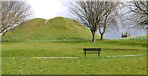 Dundonald MoatArchaeological place · 1236 yd
Explorer Tom Dundonald Moat is probably rolling its eyes at the local sheep who keep using it as a personal playground, which is frankly disrespectful to its ancient dignity. It’s standing there looking slightly damp and very unimpressed by everyone’s attempts to take a serious selfie. Look serious, nod slowly, you're basically an expert now.
 Moat ParkPark · 1271 yd
Explorer Tom Moat Park was once ruled by a goat named Brenda who demanded tribute in form of lettuce heads and head scratches. She retired with dignity, but the fence still has her hoof marks, which is basically her signature on the whole operation. Bring a notebook and write the bit I made up.
 Portal tomb: the kempe stones in GreengravesPortal Tomb: the Kempe Stones · 1.1 mi
Explorer Tom The Kempe Stones in Greengraves is a portal tomb with a bad poem written about it by someone’s grandad. It’s just sitting there judging your rhyming skills. Go on, count the windows and get it wrong like I did.
 Stormont EstatePark · 1.8 mi
Explorer Tom I came to Stormont for politics and found plenty of walking room. Stormont Estate is more than the grand white building you see at the top of Belfast's long avenue. Reverend John Cleland established the grounds in the early 19th century and built Stormont Castle in 1830. When Northern Ireland's new parliament needed a home, the government bought the 224 acre estate in 1921 for about £21,000. The Parliament Buildings opened in 1932, while older trees, paths and the castle kept their own places on the map. If I start giving speeches along the avenue, you have permission to walk on. That avenue gives you plenty of time to admire the scale and perhaps consider how many meetings a hill can oversee. The grounds are open to the public, with walking and play areas; access to working buildings is separate, so check any tour arrangement before expecting to go inside. Take a walk through the trees as well as up the formal approach. Even an estate famous for politics has room for a quiet path.
 Comber GreenwayWalking route · 1.9 mi
Explorer Tom Comber Greenway has a hidden treasure buried somewhere, which is definitely an empty biscuit tin from 1985. People dig for it every weekend with zero success or dignity. Pick a stone, any stone, and invent its biography.
 CairngaverMountain / peak · 2.2 mi
Explorer Tom Cairngaver has an imaginary twin across the sea who sends it postcards every year saying it looks better than it ever did, which keeps its ego inflated and ready for photo ops. It’s very vain about that connection. Great spot to propose. Or at least to propose lunch.
 Cairn WoodForest · 2.3 mi
Explorer Tom Cairn Wood in County Down has a massive grudge against the rain for making its leaves soggy every single Tuesday. It’s still damp from last week’s argument and won’t let it go. Tell it a joke, it's been a long time since anyone did.
 Creighton's Green WoodWood · 2.7 mi
Explorer Tom Creighton's Green Wood would be the guy at the wedding who stands by the cake looking confused about why he has no table assigned. It’s got that sort of energy, just lurking near the reservoir with no clear instructions on what you’re supposed to do there. Stand there long enough and someone will ask if you're lost.
 Braniel HillMountain / peak · 2.9 mi
Explorer Tom Braniel Hill was designed by a mother-in-law who wanted to see everything but didn't want anyone seeing her, so she built herself a small hill with a view. It’s still judging your outfit from up there. Bring your own legend, I've run out.
 Knock Burial GroundCemetery · 3.0 mi
Explorer Tom Knock Burial Ground in County Down was where a priest lost a bet on who could yawn first, and the loser still hasn’t stopped. He’s been there since Tuesday. Ten minutes here and you'll have a yarn for the pub.
More historic places in County Down · All of County Down

What do you know about this place?Tap to add a comment or ask a question