
Places near here
Photo credits
- Albert Bridge, Geograph · CC BY-SA 2.0
- Rossographer, Wikimedia Commons · CC BY-SA 2.0
- Albert Bridge, Wikimedia Commons · CC BY-SA 2.0
- William Murphy from Dublin, Ireland, Wikimedia Commons
- Gerald England, Geograph · CC BY-SA 2.0
- Stephen McKay, Geograph · CC BY-SA 2.0
- Rossographer, Geograph · CC BY-SA 2.0
- Rossographer, Geograph · Creative Commons Attribution-ShareAlike 2.0
- N Chadwick, Geograph · CC BY-SA 2.0
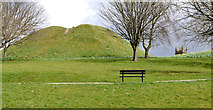 Dundonald MoatArchaeological place · 39 yd
Explorer Tom Dundonald Moat is probably rolling its eyes at the local sheep who keep using it as a personal playground, which is frankly disrespectful to its ancient dignity. It’s standing there looking slightly damp and very unimpressed by everyone’s attempts to take a serious selfie. Look serious, nod slowly, you're basically an expert now.
 Cleland MausoleumMausoleum · 98 yd
Explorer Tom Cleland Mausoleum in Church Quarter is listening to what you say through the walls, judging your life choices with silent intensity. It’s been doing that since 1850, so it’s got plenty of material. Linger, it’s not going anywhere and neither should you if you want advice.
 Presbyterian ChurchChurch · 220 yd
Explorer Tom Church Quarter’s Presbyterian Church has been around since the 1820s, so its family tree is basically a tangle of pews. A Grade B1 beauty that definitely knows who snuck a biscuit into the service last century. Bring someone who'll believe anything I say about it.
 Stormont EstatePark · 1.2 mi
Explorer Tom I came to Stormont for politics and found plenty of walking room. Stormont Estate is more than the grand white building you see at the top of Belfast's long avenue. Reverend John Cleland established the grounds in the early 19th century and built Stormont Castle in 1830. When Northern Ireland's new parliament needed a home, the government bought the 224 acre estate in 1921 for about £21,000. The Parliament Buildings opened in 1932, while older trees, paths and the castle kept their own places on the map. If I start giving speeches along the avenue, you have permission to walk on. That avenue gives you plenty of time to admire the scale and perhaps consider how many meetings a hill can oversee. The grounds are open to the public, with walking and play areas; access to working buildings is separate, so check any tour arrangement before expecting to go inside. Take a walk through the trees as well as up the formal approach. Even an estate famous for politics has room for a quiet path.
 Comber GreenwayWalking route · 1.2 mi
Explorer Tom Comber Greenway has a hidden treasure buried somewhere, which is definitely an empty biscuit tin from 1985. People dig for it every weekend with zero success or dignity. Pick a stone, any stone, and invent its biography.
 Carson's StatueMonument · 1.3 mi
Explorer Tom Carson's Statue in County Down would teach history by shouting and pointing very aggressively, I’m fairly certain. He’d probably start every lesson with 'Listen here, you lot!' and end it by throwing a hat at the slow learners. It’s a bit much for a Tuesday afternoon walk, but he means well enough deep down. Look serious, nod slowly, you're basically an expert now.
 Assembly ChamberHeritage attraction · 1.3 mi
Explorer Tom The Assembly Chamber in County Down must have taken three million cups of tea just to get the acoustics right for all those endless debates. It’s sitting empty now, probably wondering why politicians can't agree on anything simpler than who gets the window seat. Go at sunset and thank me later.
 Braniel HillMountain / peak · 2.3 mi
Explorer Tom Braniel Hill was designed by a mother-in-law who wanted to see everything but didn't want anyone seeing her, so she built herself a small hill with a view. It’s still judging your outfit from up there. Bring your own legend, I've run out.
 Knock Burial GroundCemetery · 2.3 mi
Explorer Tom Knock Burial Ground in County Down was where a priest lost a bet on who could yawn first, and the loser still hasn’t stopped. He’s been there since Tuesday. Ten minutes here and you'll have a yarn for the pub.
 Church Ruins & Graveyard: Knock/dundela in KnockChurch Ruins & Graveyard: Knock/dundela · 2.3 mi
Explorer Tom Knock/Dundela in Knock has ruins and a graveyard with stories of Agnes Murphy and her kids from 1798. Medieval stuff is always dramatic. Tell your mates you found this one first, even if you didn’t.
 The HollowWood · 3.3 mi
Explorer Tom The Hollow in County Down listens hard to the walls, convinced it can hear the ghosts arguing about whether the rain was heavy enough last Tuesday. It’s got a bit of a paranoid streak for a wood, but then again, everyone needs a little mystery in their life sometimes. Bring a camera and your most suspicious face.
 Scrabo HillMountain / peak · 3.8 mi
Explorer Tom Scrabo Hill in County Down is currently being judged by the local sheep, who think its tower looks ridiculous for something that can’t even fly. They’ve decided to stand very close to the base and stare up at it with intense disapproval, which is a lot of work for animals. Bring the dog, it'll have opinions.
More things to do in County Down · All of County Down

What do you know about this place?Tap to add a comment or ask a question