What is recorded here
There is a local tradition of a cave or possible Man-made underground passage in the interior of rath (MW028-108001-), but there is no physical evidence of it
The above description is derived from the published 'Archaeological Inventory of County Monaghan' (Dublin: Stationery Office, 1986).
From the National Monuments Service (Archaeological Survey of Ireland) record MO028-108002
The monument record does not grant public access. Check the route and ask the landowner before entering private land.
- What survives
- Recorded monument
Places near here
 kiln1300 yd
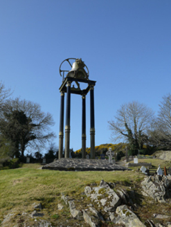 Saint Mary's Catholic ChurchBell tower/stand · 1.5 mi
 Mannan Castle (in ruins)Castle, Anglo-Norman masonry castle · 1.6 mi
 Horse-chestnut2.1 mi
 European Beech2.9 mi
 Wedge tomb in LisnadarraghWedge tomb · 6.3 mi
 Bush IslandIslet · 6.8 mi
 Fair of MuffMemorial · 8.5 mi
 Fair of MuffVisitor information · 8.5 mi
 Portal tomb in ErveyPortal tomb · 9.5 mi
 Irish Hunger StrikersMemorial · 10 mi
 Ballsmill Amenity LandPicnic place · 11 mi
Pictures: National Inventory of Architectural Heritage; Kieran Campbell, Geograph · CC BY-SA 2.0; Stephan van Helden, Wikimedia Commons · CC BY-SA 4.0; Malene Thyssen, Wikimedia Commons · CC BY-SA 3.0; Wanfried-Dublin, Wikimedia Commons · CC BY-SA 4.0; Oliver Dixon, Geograph · CC BY-SA 2.0; Eric Jones, Geograph · CC BY-SA 2.0
More archaeology and monuments in County Monaghan · All of County Monaghan
What do you know about this place?