
What is recorded here
Kiln in Laragh had two fires for cooking limestone to spread on the fields. Even by Irish standards, that’s a roundabout way of getting dinner: first roast the rocks, then feed the field, then ask how the potatoes are coming.
Rectangular-plan limestone lime kiln having buttressed corners and two flues with fire openings, built c.1850, built into a bank to rear (south), now defunct. Rubble stone walls, dressed and snecked stone to buttresses. Round arches to both fire openings,with red brick voussoirs and soffits. Exposed rock face below rubble stone wall to rear west side. Set back from road. Detached single-bay single-storey ancillary building to west of kiln, dated 1862, having pitched slate roof, roughly dressed stone walls, rendered walls to central recess to north elevation. Rubble stone boundary walls and pier, one recent rendered pier and recent gate.
This lime kiln is an industrial feature of technical interest, built to supply lime for agriculture. Lime kilns are notable structures of agricultural architecture and represent the material culture and technology of previous generations within the area. The kiln was used to burn lime to create fertilizer for the surrounding fields and to increase the alkalinity of the soil to protect animals from fluke infestations. The use of lime in this context has now been replaced by chemical fertilizers and pesticides. As this lime kiln is close to the quarries, it is likely the lime was also used for construction. The date stone to the west gable of the neighbouring building depicts a crown and the letter B, denoting the Bath Estate. It appears it may first have had a single fire opening, before being extended to the east at a later date. It makes a notable feature in the landscape today, a physical reminder of the technical and engineering skills and industriousness of its creators.
From the Buildings of Ireland (National Inventory of Architectural Heritage) record 41402811
This does not grant access. Most recorded buildings are privately owned; view them only from public ground unless the owner allows entry.
Places near here
Enclosure in DonaghmoyneEnclosure · 1174 ydTober LasairHoly well · 1232 ydTobernagalliaghSpring · 1587 yd Mannan Castle (in ruins)Castle, Anglo-Norman masonry castle · 1596 ydDonaghmoyne HouseGate lodge · 1.1 miSaint Patrick's Church (Donaghmoyne)Church/chapel · 1.3 miHorse-chestnut2.1 miEuropean Beech2.9 miKnockreaghMountain / peak · 4.1 miFincarn HillMountain / peak · 4.4 miGully IslandIslet · 4.4 miRock IslandIslet · 4.7 mi
 Mannan Castle (in ruins)Castle, Anglo-Norman masonry castle · 1596 yd
 Donaghmoyne HouseGate lodge · 1.1 mi
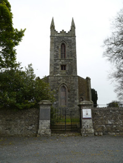 Saint Patrick's Church (Donaghmoyne)Church/chapel · 1.3 mi
 Horse-chestnut2.1 mi
 European Beech2.9 miKnockreaghMountain / peak · 4.1 miFincarn HillMountain / peak · 4.4 miGully IslandIslet · 4.4 miRock IslandIslet · 4.7 mi
Pictures: Kieran Campbell, Geograph · CC BY-SA 2.0; National Inventory of Architectural Heritage; Stephan van Helden, Wikimedia Commons · CC BY-SA 4.0; Malene Thyssen, Wikimedia Commons · CC BY-SA 3.0
More historic places in County Monaghan · All of County Monaghan
What do you know about this place?