What is recorded here
From OpenStreetMap (© OpenStreetMap contributors) n3814751738
Places near here
Photo credits
- Didier Descouens, Wikimedia Commons · CC BY-SA 4.0
- Kenneth Allen, Geograph · CC BY-SA 2.0
- National Inventory of Architectural Heritage
- Jonathan Wilkins, Wikimedia Commons · CC BY-SA 2.0
- Dean Molyneaux, Geograph · CC BY-SA 2.0
- louise price, Wikimedia Commons · CC BY-SA 2.0
- Kenneth Allen, Wikimedia Commons · CC BY-SA 2.0
- Jonathan Wilkins, Geograph · CC BY-SA 2.0
 Hawthorn1.3 mi
Explorer Tom A lovely Hawthorn tree in Donegal, possibly needing permission to enjoy its blossoms and natural grace.
 St. John's Church of Ireland ChurchChurch/chapel · 1.3 mi
Explorer Tom St. John’s Church in Killinangel Beg, an early nineteenth-century structure topped with a decorative fleur-de-lys finial.
 bridge1.3 mi
Explorer Tom Bridge in Killinangel Beg held a road over the old Donegal Town to Ballyshannon railway. Its arch has gently rough-faced stones, and the tracks were removed around 1960. I would give each stone a train whistle to practise with, but the real line has gone quiet.
 Sheebarran RingfortFairy fort / earthen ringfort · 2.3 mi
Explorer Tom Sheebarran Ringfort sits proudly on the ridge with those impressive ditches and high banks. It’s got that commanding view over the good land, which probably kept the sheep very confused.
 RossnowlaghOfficial bathing water · 2.3 mi
Explorer Tom Rossnowlagh seems determined to be a whole journey rather than one beach. Donegal tourism runs it from Coolmore’s cliffs to Carrickfad’s rock. I would need a bigger postcard for that stretch of golden sand; the surfers have probably had that problem for years.
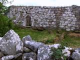 Kilbarron Old Church GraveyardGraveyard · 3.3 mi
Explorer Tom Kilbarron Old Church Graveyard features a 15th or 16th century ruin with a 2.4m high E gable that has no window at all. That is quite the dramatic lighting choice for a place meant to let in some divine brightness.
 MurvaghOfficial bathing water · 3.6 mi
Explorer Tom Murvagh Beach has a wartime lookout hut that Joy Browne, writing for Donegal tourism, remembers playing in as a child. She says erosion has since sunk it into the sand and made entry impossible. A lookout hut retiring by burying its feet is theatrical enough for me; I would leave it to its rest.
 Standing stone in Townparks (ballyshannon Ed)Standing stone · 3.7 mi
Explorer Tom Standing stone in Townparks has markings like 'cats paws' on the E side. Did a giant cat nap there? I swear I can still smell the tuna.
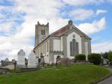 St Anne's Church GraveyardGraveyard · 3.8 mi
Explorer Tom St Anne's Church Graveyard in Ballyshannon waited two centuries for its first church to move house. That is an incredibly long commute just to change streets, but I suppose the Erne needed the space.
 Dark Cliffs at KilbarronPublicly named cliff or headland · 3.9 mi
Explorer Tom The Dark Cliffs at Kilbarron sound moody and magnificent, perfect for a quick look if you can find a safe spot.
 Kilbarron Castle in ruinsCastle, tower house · 3.9 mi
Explorer Tom Kilbarron Castle in ruins clings to a precipitous promontory, where the O'Clerys rebuilt their stronghold after 1390. I love that trace of an underground passage, though it’s blocked up now. It’s basically a cliff-edge mystery with some very stubborn stone footing.
 Wardtown StrandBeach / strand · 4.6 mi
Explorer Tom Wardtown Strand has regular navigation marker-poles indicating the sinuous river channel. I reckon those poles are doing a lot of heavy lifting while the sand just sits there, wet and unbothered. It is a very organized mess.
More mountains and hills in County Donegal · All of County Donegal

What do you know about this place?Tap to add a comment or ask a question