What is recorded here
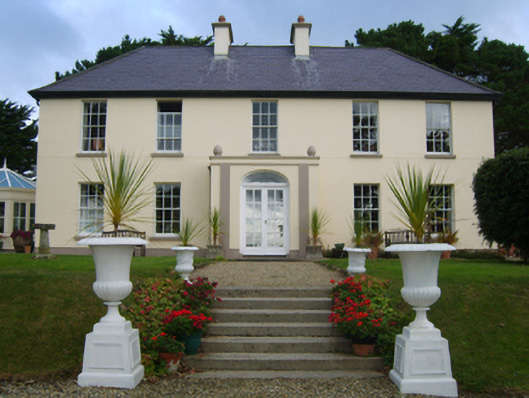
Detached five-bay two-storey double-pile farmhouse, extant 1903, on a T-shaped plan originally five-bay two-storey on a rectangular plan centred on single-bay single-storey flat-roofed projecting porch to ground floor; three-bay two-storey rear (north) elevation centred on single-bay full-height breakfront on an engaged half-octagonal plan. Occupied, 1911. Extended, 2005, producing present composition. Replacement hipped double-pile (M-profile) slate roof with clay ridge tiles, paired rendered central chimney stacks having corbelled stepped capping supporting terracotta tapered pots, and uPVC rainwater goods on box eaves. Replacement cement rendered walls bellcast over rendered plinth. Elliptical- or segmental-headed central door opening with concrete step threshold, and concealed dressings framing glazed timber double doors having overlight. Elliptical- or segmental-headed door opening into farmhouse with concealed dressings framing glazed timber panelled double doors having overlight. Square-headed window openings including square-headed window openings to rear (north) elevation with cut-granite sills, and concealed dressings framing six-over-six timber sash windows. Set in landscaped grounds including terrace centred on flight of six concrete steps.
A farmhouse representing an integral component of the nineteenth-century domestic built heritage of south County Wexford with the architectural value of the composition, one succeeding an eighteenth-century house (1760) marked on the first edition of the Ordnance Survey (surveyed 1840; published 1841; Rowe and Scallan 2004, 677), suggested by such attributes as the deliberate alignment maximising on scenic vistas overlooking rolling grounds and Lady's Island Lake; the symmetrical frontage centred on a restrained doorcase, albeit one largely concealed behind a later porch; and the uniform or near-uniform proportions of the openings on each floor. Having been well maintained, the elementary form and massing survive intact together with quantities of the original or sympathetically replicated fabric, thus upholding much of the character or integrity of a farmhouse having historic connections with the Furlong family including Philip Furlong (Wexford County Archives 1922).
This does not grant access. Most recorded buildings are privately owned; view them only from public ground unless the owner allows entry.
Places near here
 Field system in Butlerstown (forth By., Kilscoran Ed)Field system · 404 yd
 farm housefarm house · 554 yd
 Enclosure in TraneEnclosure · 621 yd
 Ballytory Castlefarm house · 735 yd
 ScargeenIsland · 814 yd
 Lady's IslandVisitor information · 1068 yd
 TowerBawn · 1087 yd
 CastleHouse, fortified house · 1242 yd
 InishIsland · 1324 yd
 Shernock Hill/Knocks HillMountain / peak · 2.0 mi
 Carne BeachBeach / strand · 2.1 mi
 The Chour / The Hill of the ChourMountain / peak · 2.1 mi
Other information
Photo: National Inventory of Architectural Heritage · Website use allowed for educational or private purposes with source credit