What is recorded here
Places near here
Picture notes
- Computer-made picture. It does not show this playground.
- The original uploader was Suckindiesel at English Wikipedia ., Wikimedia Commons · CC BY 2.5
- National Inventory of Architectural Heritage
- Sitomon, Wikimedia Commons · CC BY-SA 2.0
- Olivier BEZES, Wikimedia Commons · CC BY 2.5
- Architecture of Dublin, Wikimedia Commons · Public domain
- JP, Geograph · CC BY-SA 2.0
 Dun Laoghaire-Rathdown County CouncilChildren's playground · 188 ydComputer-made picture. It does not show this playground.
Explorer Tom Dun Laoghaire-Rathdown County Council playground in County Dublin is open but secretive. No notes, so maybe the sandpit contains pirate gold? Show me what you find!
 IndicatedMound · 376 yd
Explorer Tom Mound in Haroldsgrange is a tree-topped circle that’s part of a linear earthwork, so it’s like a dot at the end of a sentence. Locals say stepping on it brings bad luck or good cheese. Take a mate and argue about what it was for.
 The Bottle TowerRuins · 738 yd
Explorer Tom The Bottle Tower in County Dublin sounds like my idea of a bar. Probably full of old bottles and even older stories. I bet it smells like lavender and regret. Take a pic for the group chat, mate!
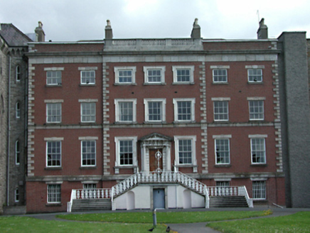 Rathfarnham HouseCountry house · 748 yd
Explorer Tom Rathfarnham House is having a bit of a feud with the rain, claiming it knows how to stand tall even when wet. It’s an early 1800s show-off with some fine detailing that makes you want to stare. Visit, then text me back.
 Bright HorizonsChildren's playground · 815 ydComputer-made picture. It does not show this playground.
Explorer Tom Bright Horizons in County Dublin sounds like it’s promising too much again. Probably just a slide and a very ambitious name. Enjoy the bright future, yeah?
WhitecliffVisitor information · 1350 ydExplorer Tom Whitecliff in County Dublin sounds like a cliff. It’s actually just a visitor info spot, which is weirdly anticlimactic for such a dramatic and rocky-sounding name.
 European Yew1368 yd
Explorer Tom European Yew in County Dublin has been feuding with the rain since the last ice age or something equally dramatic. It looks grumpy, which is on brand for a yew that’s seen too much drama. Go on a wet day, it suits the gloomy mood perfectly.
ObeliskMemorial · 1414 ydExplorer Tom Obelisk in County Dublin stands on Killiney Hill, which sounds like a great place for a picnic. It's a memorial, so probably someone important died or did something cool. Climb up the hill and take a picture with the tall pointy thing!
 Lebanon Cedar1.1 mi
Explorer Tom Lebanon Cedar in County Dublin smells like expensive soap and old money, according to Tom, who has never been there but knows everything. It’s trying too hard to be fancy for a tree that just wants to stand still. Ring your granny and tell her where you are before you get lost in the scent.
 Rathgar CastleCastle, unclassified · 1.5 mi
Explorer Tom Rathgar Castle was involved in the Battle of Rathmines in 1649. Beranger drew it in ruin in 1769, looking quite dramatic. Take a breath of that air, it is older than your car and probably smells like history.
 Austin Clarke BridgeMemorial · 1.7 mi
Explorer Tom Austin Clarke Bridge in County Dublin is named after a poet who lived nearby, so cross it slowly and try to compose a verse about the river that doesn’t rhyme badly.
 Clonskeagh CastleCastle · 1.8 mi
Explorer Tom Clonskeagh Castle in County Dublin used to be called Roebuck and belonged to a United Irishman ironfounder. History says it was still being fixed up back in 1789, so it has plenty of drama.
More things to do in County Dublin · All of County Dublin
What do you know about this place?Tap to add a comment or ask a question