
What is recorded here
Internal diam. 28.4m N-S, 19m E-W Lisnatelimy/Lios na bhFeidhlimí: This well-preserved bivallate rath is located on level pasture, W of the Cottoners river and directly S of Killorglin town. The outer bank is extant only along the N sector, where it measures 1.6m high externally, 1.75m wide and falls 2m to the bottom…
Read the whole record
From the National Monuments Service (Archaeological Survey of Ireland) record KE056-041
Places near here
Photo credits
- Maker not stated on source page, tr.pinterest.com
- Maker not stated on source page, www.irelandhighlights.com
- Maker not stated on source page, www.flickr.com
- Maker not stated on source page, www.pinterest.com
- National Inventory of Architectural Heritage
- Ian S, Geograph · CC BY-SA 2.0
- Ridiculopathy, Wikimedia Commons · CC BY-SA 4.0
- Maker not stated on source page, ru.pinterest.com
 Fairy fort / earthen ringfort in ArdacluckeenFairy fort / earthen ringfort · 1188 yd
Explorer Tom Fairy fort in Ardacluckeen is by the Cottoners river, where legend says a giant once tripped over his own feet and…
 Fairy fort / earthen ringfort in KnocknaboolaFairy fort / earthen ringfort · 1559 yd
Explorer Tom Fairy fort / earthen ringfort in Knocknaboola is named Lissaghaunbeg, which sounds like a giant who got stuck in a…
 Standing stone in ArdmoneelStanding stone · 1625 yd
Explorer Tom Standing stone in Ardmoneel is gone, probably because the map makers got their directions mixed up with a pub sign.…
 Fairy fort / earthen ringfort in Kilcoolaght WestFairy fort / earthen ringfort · 1687 yd
Explorer Tom Fairy fort / earthen ringfort in Kilcoolaght West had a fox take charge of security for about two years. The fox left…
Fairy fort / earthen ringfort in ArdmoneelFairy fort / earthen ringfort · 1.1 miExplorer Tom Fairy fort / earthen ringfort in Ardmoneel ended up in the wrong place because someone moved a house on top of it. It’s…
 Fairy fort / earthen ringfort in Dromavally (trughanacmy By., Killorglin Ed)Fairy fort / earthen ringfort · 1.4 mi
Explorer Tom Fairy fort / earthen ringfort in Dromavally has no data, so I’m guessing it’s shy and hates small talk. Its dating…
 Fairy fort / earthen ringfort in DunmaniheenFairy fort / earthen ringfort · 1.5 mi
Explorer Tom Fairy fort / earthen ringfort in Dunmaniheen wants to complain to the council about its view. It has a bank that barely…
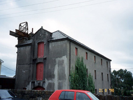 store/warehouse1.5 mi
Explorer Tom The store in Farrantoreen has an iron chute that looks like a shortcut but is actually just a very bad idea. It’s been…
 Saint Michael's Church (Killorglin)Church/chapel · 1.6 mi
Explorer Tom Saint Michael’s Church in Killorglin has been closed since ’97, but it’s definitely still judging you from the window.…
 Ogham stone in Kilcoolaght EastOgham stone · 1.6 mi
Explorer Tom Ogham stone in Kilcoolaght East is wearing its best face while hiding behind those iron railings. Apparently, a church…
 Church in Kilcoolaght EastChurch · 1.6 mi
Explorer Tom Church in Kilcoolaght East is so old it remembers when the hills were actually mountains and the clouds used to be…
 garage1.6 mi
Explorer Tom The Garage in Farrantoreen is all ball finials and pretense, pretending to be a mansion when it’s just a shed for cars.…
More archaeology and monuments in County Kerry · All of County Kerry

What do you know about this place?Tap to add a comment or ask a question