What is recorded here
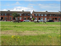
On pasture at N edge of a ridge running E-W within the demesne lands of Mount Shannon House located 470m to SW. 'Cromwell's Road' (LI006-007----) lies 100m to E. Site inspected by Celie O’Rahilly, archaeologist, Limerick Corporation on 30/09/1997 (SMR File). Not indicated on the 1840 ed. OS 6-inch map. Annotated 'Lisnagry' on the Cassini 6-inch OS map where it is depicted as a circular shaped platform (approx. diam. 27m) defined by a scarp. Outline of the monument is clearly visible on Digital Globe orthophotos taken 2011-13. Remains consist of a circular-shaped area (approx. int. diam. 29m) enclosed by an earthen bank with external fosse (approx. Wth 6-7m) which is barely visible at SE possibly due to the presence of an original entrance feature. Boundary of property to N cuts across enclosing fosse of ringfort at NW as clearly indicated on Google earth orthophoto taken 19/11/2019. See attached Google Earth orthoimages
Compiled by: Edmond O’Donovan
Date of upload: 10 July 2020
On pasture at N edge of a ridge running E-W within the demesne lands of Mount Shannon House located 470m to SW. 'Cromwell's Road' (LI006-007----) lies 100m to E. Site inspected by Celie O’Rahilly, archaeologist, Limerick Corporation on 30/09/1997 (SMR File). Not indicated on the 1840 ed. OS 6-inch map. Annotated 'Lisnagry' on the Cassini 6-inch OS map where it is depicted as a circular shaped platform (approx.…
From the National Monuments Service (Archaeological Survey of Ireland) record LI006-006
The monument record does not grant public access. Check the route and ask the landowner before entering private land.
- What survives
- Recorded monument
Places near here
Photo credits
- National Inventory of Architectural Heritage
- Mike Searle, Geograph · CC BY-SA 2.0
- David Hawgood, Geograph · CC BY-SA 2.0
- Garry Dickinson, Wikimedia Commons · CC BY-SA 2.0
- SirGarick, Wikimedia Commons · CC BY-SA 4.0
 Mount ShannonIcehouse · 546 yd
 Country house in MountshannonCountry house · 553 ydEnclosure in MountshannonEnclosure · 633 ydBarrowBarrow, unclassified · 1465 yd
 Jackie PowerMemorial · 1.4 mi
_-_geograph.org.uk_-_6519496.jpg/250px-Castles_of_Munster,_Castle_Troy,_Limerick_(1)_-_geograph.org.uk_-_6519496.jpg "Photo: Garry Dickinson, Wikimedia Commons · CC BY-SA 2.0") Castle Troy (in ruins)Castle, tower house · 1.7 mi
Castle Troy (in ruins)Castle, tower house · 1.7 mi Castle ConnellRuins · 1.9 miCampus MapVisitor information · 2.5 miCampus MapVisitor information · 2.6 miFountain SculptureHeritage attraction · 2.7 miSeán Keating GalleryGallery · 4.5 mi
 King's IslandIsland · 4.8 mi
More archaeology and monuments in County Limerick · All of County Limerick
What do you know about this place?