What is recorded here
A section of Pale boundary, according to Ball & Hamilton (1895, 8-9) the Pale began at Dalkey and followed a south-westerly course towards Kiltiernan.
From the National Monuments Service (Archaeological Survey of Ireland) record DU023-039
The monument record does not grant public access. Check the route and ask the landowner before entering private land.
- What survives
- Recorded monument
Places near here
Photo credits
- Palanitboy, Wikimedia Commons · CC BY-SA 4.0
- Mike Searle, Wikimedia Commons · CC BY-SA 2.0
- Kevin Forkan, Wikimedia Commons · CC BY-SA 4.0
- JacK93, Wikimedia Commons · CC BY-SA 4.0
- The original uploader was Irishpunktom at English Wikipedia ., Wikimedia Commons · CC BY-SA 3.0
- Aleks Scholz, Geograph · CC BY-SA 2.0
- JP, Geograph · CC BY-SA 2.0
St. Begnets WellHoly well · 232 ydTown defences in DalkeyTown defences · 294 yd Dalkey CastleFortified town house and castle · 310 ydCastleCastle, tower house · 310 ydArchbold's CastleCastle · 314 ydDalkey Heritage CentreVisitor information · 324 ydChurch in DalkeyChurch · 330 ydIndicated as Dalkey LodgeHouse, 16th/17th century · 490 ydDalkey HillMountain / peak · 648 ydThomas Higgin MemorialMemorial · 728 ydHawk CliffCliff · 942 ydHawk CliffCliff · 946 yd
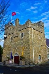 Dalkey CastleFortified town house and castle · 310 yd
 CastleCastle, tower house · 310 yd
 Archbold's CastleCastle · 314 ydDalkey Heritage CentreVisitor information · 324 yd
 Church in DalkeyChurch · 330 ydIndicated as Dalkey LodgeHouse, 16th/17th century · 490 yd
 Dalkey HillMountain / peak · 648 ydThomas Higgin MemorialMemorial · 728 yd
 Hawk CliffCliff · 942 yd
 Hawk CliffCliff · 946 yd
More archaeology and monuments in County Dublin · All of County Dublin
What do you know about this place?