What is recorded here
The S defences of the medieval borough of Dalkey are defined by a dense hedge line that runs along a linear escarpment in the slope (H 2m) and forms the S limit of the burgage plots that fronts onto Castle Street in Dalkey Village. A possible associated bank (Wth 3m, H 2m) has been identified behind Bay View House and Melrose. It is bounded by Cunningham Road to the S and Dalkey Avenue to the W. The W line of defence of Dalkey may be represented by a long linear boundary running S from Barnhill Road, to the corner of Green Banks House (326441/226915). The E end of Castle Street probably marks the limit of the medieval town on the E side. The N limit has not been identified. Excavations in 1996 at 59 Castle Street uncovered a ditch directly below the partition wall between houses No. 7 and No. 8 which may represent the S extent of a burgage plot (96E0297; Murtagh, 1997, 18). In 1482 the bailiff of Dalkey was granted the right to levy customs on all goods and merchandise coming into Dalkey and to use the money for murgage and pavage (McNeill 1950, 247).
The S defences of the medieval borough of Dalkey are defined by a dense hedge line that runs along a linear escarpment in the slope (H 2m) and forms the S limit of the burgage plots that fronts onto Castle Street in Dalkey Village. A possible associated bank (Wth 3m, H 2m) has been identified behind Bay View House and Melrose. It is bounded by Cunningham Road to the S and Dalkey Avenue to the W. The W line of…
From the National Monuments Service (Archaeological Survey of Ireland) record DU023-023016
The monument record does not grant public access. Check the route and ask the landowner before entering private land.
- What survives
- Recorded monument
Places near here
Photo credits
- Palanitboy, Wikimedia Commons · CC BY-SA 4.0
- Mike Searle, Wikimedia Commons · CC BY-SA 2.0
- Mike Searle, Geograph · CC BY-SA 2.0
- JacK93, Wikimedia Commons · CC BY-SA 4.0
- The original uploader was Irishpunktom at English Wikipedia ., Wikimedia Commons · CC BY-SA 3.0
- JP, Geograph · CC BY-SA 2.0
- Aleks Scholz, Geograph · CC BY-SA 2.0
- YvonneM, Wikimedia Commons · CC BY-SA 3.0
- Darrin Antrobus, Geograph · CC BY-SA 2.0
- Gareth James, Geograph · CC BY-SA 2.0
- Nick Lansley, Wikimedia Commons · CC BY-SA 3.0
- David Dixon, Geograph · CC BY-SA 2.0
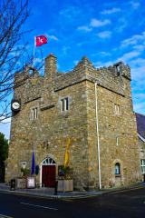 Dalkey CastleFortified town house and castle · 30 yd
 CastleCastle, tower house · 31 yd
 CastleCastle, unclassified · 44 yd
 Church in DalkeyChurch · 63 yd
 Dalkey HillMountain / peak · 935 yd
 Hawk CliffCliff · 1160 yd
 Hawk CliffCliff · 1174 yd
 James Joyce Tower and MuseumMuseum · 1461 yd
 Sandycove BeachBeach / strand · 1478 yd
 White Rock, Killiney BeachBeach / strand · 1545 yd
 St Begnets ChurchChurch · 1545 yd
 Martello Tower1628 yd
More archaeology and monuments in County Dublin · All of County Dublin
What do you know about this place?