What is recorded here
Situated on the S side of Barnhill Road, part of a multi-period residence named Dalkey Lodge on the First OS 6-inch edition maps, set with in gardens as a detached house. The earlier house, a rectangular, 2-storey rendered masonry structure is placed with its long axis facing the street along an ENE-WSW axis. The adjoining 18th century house, following the same alignment is set back a little from the earlier structure. The earlier structure consists of rectangular 2-storey rendered masonry house, 9.4m E-W and 6.7m N-S externally, with a flat-headed entrance at ground floor level and a flat-headed but internally splayed window embrasure at first-floor level. On the south front there are two large flat-headed openings which are not original at ground and first floor level. According to the deeds this house was first constructed in 1658 just off the Barnhill Road (pers. comm. Marguerite Ryan). The later structure is a five bay double pile house with steeply pitched roof, expressed chimneys and centrally placed Gibbs doorway. In the later 18th century the house was again extended to the S. Complied by: Margaret Keane and Padraig Clancy
Revised upload on: 6 July 2018
Situated on the S side of Barnhill Road, part of a multi-period residence named Dalkey Lodge on the First OS 6-inch edition maps, set with in gardens as a detached house. The earlier house, a rectangular, 2-storey rendered masonry structure is placed with its long axis facing the street along an ENE-WSW axis. The adjoining 18th century house, following the same alignment is set back a little from the earlier…
From the National Monuments Service (Archaeological Survey of Ireland) record DU023-070
The monument record does not grant public access. Check the route and ask the landowner before entering private land.
- What survives
- Recorded monument
Places near here
Photo credits
- DDoghaus, Wikimedia Commons · CC BY-SA 4.0
- Kevin Forkan, Wikimedia Commons · CC BY-SA 4.0
- JacK93, Wikimedia Commons · CC BY-SA 4.0
- Palanitboy, Wikimedia Commons · CC BY-SA 4.0
- The original uploader was Irishpunktom at English Wikipedia ., Wikimedia Commons · CC BY-SA 3.0
- Darrin Antrobus, Geograph · CC BY-SA 2.0
- YvonneM, Wikimedia Commons · CC BY-SA 3.0
- Aleks Scholz, Geograph · CC BY-SA 2.0
- JP, Geograph · CC BY-SA 2.0
- Gareth James, Geograph · CC BY-SA 2.0
 Castle (in ruins)Castle, tower house · 383 yd
 Archbold's CastleCastle · 384 yd
 Church in DalkeyChurch · 429 yd
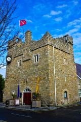 Dalkey CastleFortified town house and castle · 451 ydDalkey Heritage CentreVisitor information · 455 ydTown defences in DalkeyTown defences · 472 yd
 Dalkey HillMountain / peak · 1015 yd
 Sandycove BeachBeach / strand · 1376 yd
 James Joyce Tower and MuseumMuseum · 1380 yd
 Hawk CliffCliff · 1399 yd
 Hawk CliffCliff · 1416 yd
 White Rock, Killiney BeachBeach / strand · 1528 yd
More historic places in County Dublin · All of County Dublin
What do you know about this place?