Places near here
Photo credits
- Kenneth Allen, Wikimedia Commons · CC BY-SA 2.0
- Ronnie Nijboer, Wikimedia Commons · CC0
- National Inventory of Architectural Heritage
- Eric Jones, Geograph · CC BY-SA 2.0
- Rossographer, Geograph · CC BY-SA 2.0
- Richard Webb, Geograph · CC BY-SA 2.0
- Kenneth Allen, Geograph · CC BY-SA 2.0
- louise price, Wikimedia Commons · CC BY-SA 2.0
- louise price, Geograph · CC BY-SA 2.0
- Mhdelaney, Wikimedia Commons · CC BY-SA 4.0
 Letterilly Standing StonePublicly named standing stone · 203 yd
Explorer Tom Letterilly Standing Stone is standing there all by itself, probably wondering why it didn't get invited to the more exciting stone circles nearby. It’s a lovely bit of quiet company if you need a moment to think about how old the ground really is. Just make sure you ask permission before you start having a chat with it.
 Wych Elm1.2 mi
Explorer Tom Wych Elm claims there’s a shortcut through its branches that saves twenty minutes, but nobody has ever actually found the exit yet. People get lost in the canopy and end up climbing down on the same side they started from. It’s a bit of a trickster with a green exterior. Bring a flask of something warm and a story to swap.
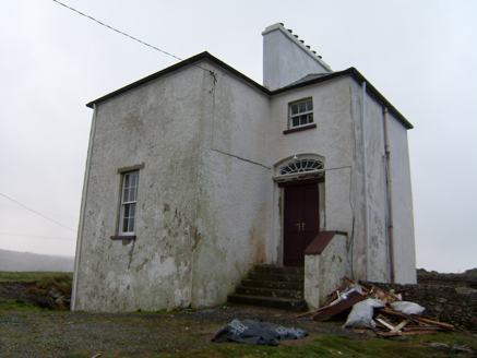 The Old RectoryRectory/glebe/vicarage/curate's house · 2.0 mi
Explorer Tom The Old Rectory built in 1828 has false windows on its front, which makes me think it’s just shy and doesn’t want anyone peeping inside. I bet those fake panes are waiting for a real ghost to move in, just to prove they’re not actually doors.
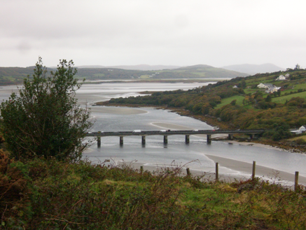 Droichead Ghaoth Beara [Gweenbarra Bridge]Bridge · 2.1 mi
Explorer Tom Droichead Ghaoth Beara [Gweenbarra Bridge] crossed the Gweebarra River in 1953 with nine main spans and a half-span at each end, replacing an older girder bridge. I need an extra finger just to count the pieces. That's a serious river crossing.
 Gweebarra BarPub · 2.5 mi
Explorer Tom Gweebarra Bar sits right on a sharp bend in the N56, waiting for someone to lose control of their vehicle. The seagulls outside are already drafting a scathing review of the interior lighting and the beer selection. Bring the dog, it will definitely have strong opinions about the décor.
 Bonny Glen Wood - Bonny Glen walkOfficial walking route · 2.6 mi
Explorer Tom Bonny Glen Wood - Bonny Glen walk would bring a bottle of wine and a very serious face to any party it attended. It had a fire in 2011 and now acts like it’s been through therapy and came out stronger. A proper spot for a flask of tea and a big think.
 Highlands HotelHotel · 2.8 mi
Explorer Tom Highlands Hotel in Glenties sounds like it’s on top of a mountain with no lift to help you. If you see a view, describe it to me, but don’t mention the cold draft. Find a local and ask them the real story, then come back and tell me.
 St. Connell's Museum and Heritage CentreMuseum · 2.8 mi
Explorer Tom St. Connell's Museum and Heritage Centre lets me go from an old courtroom to the cells below, then into stories of the workhouse and Donegal railways. That is a lot of Glenties history packed into one building. I would leave the cells to the displays and keep my own visit on the friendly side of the door.
 Burial GroundGraveyard · 3.0 mi
Explorer Tom Burial Ground in Kilrean Upper is stacked with layers of history that refuse to stay quiet. You’ve got 12th-century sandstone window heads and a cross-slab with swastika patterns sitting right next to modern graves. It’s a bit of a chaotic archaeological buffet, so keep your eyes peeled for the odd carvings.
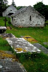 Inishkeel Graveyard near GlentiesGraveyard · 3.7 mi
Explorer Tom Inishkeel Graveyard near Glenties was rectangular in the older survey, but its south side sat on part of a roughly circular rise. Some of that rise lay beyond the west wall, about fifty metres across. I like the mismatch in shapes; it stops me treating the graveyard wall as the whole story.
 DooeyOfficial bathing water · 4.4 mi
Explorer Tom Dooey seems to have let the Gweebarra estuary and a headland book its two ends. Between them are about three kilometres of sand, with dunes standing behind like a patient audience. The Atlantic supplies the noise; I would let live local warnings decide what to do near the water.
 Narin–Portnoo StrandOfficial bathing water · 4.6 mi
Explorer Tom Narin–Portnoo Strand is a cove with grand ambitions: about two kilometres of sand and a dune ridge behind it. Dunmore Head takes some of the Atlantic’s edge, while Inishkeel sits out front like it reserved the best seat. I would keep that island on my map, with the tide as its own boss.
More archaeology and monuments in County Donegal · All of County Donegal

What do you know about this place?Tap to add a comment or ask a question