
Places near here
Photo credits
- Jim Woodward-Nutt, Geograph · Creative Commons Attribution-ShareAlike 2.0
- Hywel Williams, Geograph · CC BY-SA 2.0
- Joebater at English Wikipedia, Wikimedia Commons · CC BY-SA 3.0
- Donald MacDonald, Geograph · CC BY-SA 2.0
- Kmcnamee, Wikimedia Commons · CC BY-SA 4.0
- Maker named on the Wikimedia Commons picture page · CC BY-SA 2.5
- me, Wikimedia Commons · Public domain
- Ceoil ( talk ) ( Uploads ), Wikimedia Commons · Public domain
- Jonathan Thacker, Geograph · CC BY-SA 2.0
 Bealick MillMill (water) · 69 yd
Explorer Tom Bealick Mill in Bealick is spinning its wheels and pretending it's still grinding corn from the Napoleonic wars. The…
 Bealick Mill (Corn)Mill, corn · 70 yd
Explorer Tom Bealick Mill (Corn) is on the river bank, which means it's always getting wet socks if you try to touch it. There's a…
Ancient Burial (Site of)Cist · 952 ydExplorer Tom Ancient Burial in Bealick is a tiny stone-lined cist that got examined by O'Kelly and found with an encrusted urn…
St Bernards WellHoly well · 1023 ydExplorer Tom St Bernards Well has cement steps and a plaque for a saint whose name sounds like a sneeze. People used to do rounds…
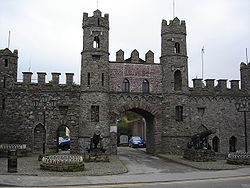 Battle of MacroomBattle · 1231 yd
Explorer Tom The Battle of Macroom is constantly trying to one-up its more famous cousin next door by claiming it had better weather…
 Macroom Castle (in Ruins)Castle, tower house · 1599 yd
Explorer Tom Macroom Castle got demolished in 1967 to build a technical school, which is either genius or terrible. The bargain was…
 Bishop McEgan Park, MacroomGAA ground · 1676 ydTom Creedon Park, MacroomGAA ground · 1.4 mi
 Sessile Oak1.8 mi
Explorer Tom Sessile Oak in County Cork would post on social media: 'Another day, another leaf falling. #NatureIsIndifferent.' It’s…
 The Gearagh Nature ReserveNature reserve · 2.9 mi
Explorer Tom The Gearagh Nature Reserve remembers the time a priest lost a bet there and had to wear a penguin suit for a week…
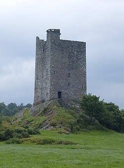 Carrigaphooca CastleCastle · 3.8 mi
Explorer Tom Carrigaphooca Castle has a púca in its name and a rock under its feet, enough for me to spin a tale before we even…
 Kilmurry WoodsPicnic place · 4.7 mi
Explorer Tom Kilmurry Woods in County Cork had a fiddler play there all night last Tuesday, and the trees are still shaking their…
More historic places in County Cork · All of County Cork

What do you know about this place?Tap to add a comment or ask a question