
What is recorded here
On N bank of Laney River, near its confluence with Sullane River. Indicated on 1842 OS 6-inch map as 'Bealick Mills', with millrace approaching from E, which also powered a tuck mill (no longer surviving) c. 400m to E. By 1901 OS 6-inch map shows millrace rerouted, approaching 'Bealick Mill (Corn)' from N.…
Read the whole record
From the National Monuments Service (Archaeological Survey of Ireland) record CO071-016
Places near here
Photo credits
- Jim Woodward-Nutt, Wikimedia Commons · CC BY-SA 2.0
- National Inventory of Architectural Heritage
- Sole Origami, Wikimedia Commons · CC BY-SA 4.0
- Joebater at English Wikipedia, Wikimedia Commons · CC BY-SA 3.0
- Donald MacDonald, Geograph · CC BY-SA 2.0
- Maker named on the Wikimedia Commons picture page · CC BY-SA 2.5
- me, Wikimedia Commons · Public domain
- Ceoil ( talk ) ( Uploads ), Wikimedia Commons · Public domain
- Jonathan Thacker, Geograph · CC BY-SA 2.0
 Bealick MillVisitor attraction · 5 yd
 Firville HouseGate lodge · 55 yd
Explorer Tom Firville House in Bealick looks like a shed that got lost on the way to the party. Corrugated roof? Bold choice. Pretend you didn't see it slouching.
 Laney BridgeBridge · 70 yd
Explorer Tom Laney Bridge in Bealick is bragging about surviving storms that would’ve flattened a normal structure. It carries way more traffic than its original builders ever dreamed of, which is funny given the date. Ask it how it feels being a landmark for heavy trucks now.
Ancient Burial (Site of)Cist · 921 ydExplorer Tom Ancient Burial in Bealick is a tiny stone-lined cist that got examined by O'Kelly and found with an encrusted urn inside. It’s 0.5 meters long, which is barely bigger than a bread loaf, making the whole archaeological process feel like opening a very old lunchbox. Tell the kids it's a castle. Close enough.
St Bernards WellHoly well · 1089 ydExplorer Tom St Bernards Well has cement steps and a plaque for a saint whose name sounds like a sneeze. People used to do rounds here on Palm Sunday while pretending they weren't sweaty. Stand still and listen, the wind tells it better than me.
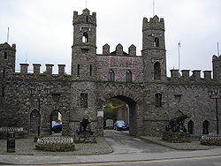 Battle of MacroomBattle · 1210 yd
Explorer Tom Battle of Macroom in County Cork had a fake royal visit that nobody can disprove to this day. Ideal for a moody photo you'll pretend wasn't posed, just for the 'gram.
 Macroom Castle (in Ruins)Castle, tower house · 1575 yd
Explorer Tom Macroom Castle was demolished to build a technical school, which is the kind of insult only Cork can pull off. It used to have two square towers that were just too much hassle. Bring a camera and your most suspicious face for the school.
Macroom WalksVisitor information · 1698 yd Sessile Oak1.8 mi
Explorer Tom Sessile Oak in County Cork is having a mid-life crisis, refusing to shed its leaves like a normal tree. Spot the oldest stone and give it a name that sounds expensive.
 The Gearagh Nature ReserveNature reserve · 2.9 mi
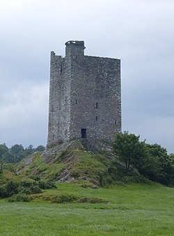 Carrigaphooca CastleCastle · 3.7 mi
Explorer Tom Carrigaphooca Castle in County Cork is keeping its mouth shut. It's just recorded as a castle, which is boring but honest. Don't be shy; take a photo for me if it looks interesting at all.
 Kilmurry WoodsPicnic place · 4.8 mi
More historic places in County Cork · All of County Cork

What do you know about this place?Tap to add a comment or ask a question