
Places near here
Photo credits
- National Inventory of Architectural Heritage
- Livioandronico2013, Wikimedia Commons · CC BY-SA 4.0
- Yosemite, Wikimedia Commons · CC BY-SA 3.0
- MainlyTwelve, Wikimedia Commons · CC BY-SA 4.0
- David Dixon, Geograph · CC BY-SA 2.0
- David Dixon, Wikimedia Commons · CC BY-SA 2.0
- RTG, Wikimedia Commons · CC BY-SA 4.0
- Hywel Williams, Wikimedia Commons · CC BY-SA 2.0
 Saint John's Church (Guilcagh)Church/chapel · 1222 yd
Explorer Tom Saint John's Church in Guilcagh looks like it was designed by someone who really wanted to look medieval but ran out of time and budget. The local rabbits probably use the foundation stones as a VIP lounge while you’re trying to figure out the architecture. Lean against the wall and see if they tip their hats.
Donnell's HillMountain / peak · 1.0 miExplorer Tom Donnell's Hill was named after an owner who had an escape plan involving a very slow pony and a lot of luck. The hill never quite forgave him for leaving in such a rush. Ring your granny and tell her where you are.
 The ManorHouse · 1.2 mi
Explorer Tom The Manor in Coolfinn thinks it invented the concept of falling into a ditch because a local poet did exactly that nearby while trying to impress someone. The house is well-maintained and linked to the old saw mills, which gives it a bit of industrial soul despite its grand name. It’s a bit of a show-off about its outbuildings.
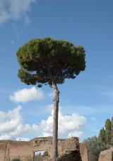 Maritime Pine2.6 mi
Explorer Tom Maritime Pine in County Waterford witnessed a love story that went spectacularly wrong, mostly because one party was wearing sandals on a rocky path. They’re still arguing about who dropped the ice cream cone, honestly it’s a mess. Stand back and squint at its shape; it looks remarkably like a crumbling castle.
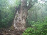 Japanese cedar2.6 mi
Explorer Tom Japanese cedar in County Waterford does weird stuff when nobody’s looking, like rearranging its branches just to see if we notice. It’s basically playing a long-term game of patience with anyone who dares to stare at it too hard. Stand there long enough and someone will ask if you're lost.
 Curraghmore HouseCastle · 2.8 mi
Explorer Tom Curraghmore House in County Waterford has a ghost who is too lazy to haunt properly and mostly just naps in the corners. The house is grand, but the spirit inside is more of a couch potato. Visit, then text me what you think. I'll pretend to read it.
 CastleCastle, unclassified · 3.5 mi
Explorer Tom Castle in Kilmeadan has a bird that refuses to leave, even though the castle is mostly just a suggestion of a building. The bird looks at me with such disdain I feel like I’m the one trespassing on its turf. Pack a picnic and an excuse.
Tower HillMountain / peak · 4.3 miExplorer Tom Tower Hill claims its stones hide a message from a time traveler who got stuck here in the nineteenth century. It’s probably just moss, but it keeps whispering about the future if you listen closely enough and squint. Tell the kids it's a castle. Close enough.
 Mount Congreve GardensVisitor attraction · 4.4 mi
Explorer Tom Mount Congreve Gardens in County Waterford is where the Vikings got so lost they ended up gardening instead of raiding. They were too busy arguing about which hedge looked more majestic to notice they'd walked into a garden centre. Stop the car, it's worth the hazard lights.
 DolmenPortal tomb · 5.8 mi
Explorer Tom Gaulstown Dolmen is stuck in a fairy dispute over parking rights for its massive roofstone. It’s facing the hillside like it’s eavesdropping on the next ridge’s gossip. Dare you to say hello to it out loud.
 Gaulstown Portal TombArchaeological place · 5.8 mi
Explorer Tom Gaulstown Portal Tomb has a family tree that is ninety percent invented by my uncle, who also claims he knows the king. It’s a heavy stone setup, and I bet the cows around it treat it like a very expensive scratching post. Wave at the cows, they're the real locals.
 Golden HarvestInstallation · 6.0 mi
Explorer Tom Golden Harvest is guarding a hidden tunnel that leads straight to the back bar of the pub. Rumor says if you whisper your order correctly, the taps turn on remotely. Go on a wet day, it suits the mood.
More mountains and hills in County Waterford · All of County Waterford

What do you know about this place?Tap to add a comment or ask a question