What is recorded here
From OpenStreetMap (© OpenStreetMap contributors) n4311284595
Places near here
Photo credits
- Maker not stated on source page, www.irelandhighlights.com
- Rossographer, Geograph · CC BY-SA 2.0
- National Inventory of Architectural Heritage
- Maker not stated on source page, yandex.ru
- Joseph Mischyshyn, Wikimedia Commons · CC BY-SA 2.0
- Maker not stated on source page, www.youtube.com
- Maker not stated on source page, commons.wikimedia.org
- Liamfm ., flickr
- Maker not stated on source page, en.wikipedia.org
- Golfing in Ireland; photographer not stated, Source publisher
 Southern Bloody Foreland EnclosureEnclosure · 728 yd
Explorer Tom Down south we find the Southern Bloody Foreland Enclosure, which uses a long arc of stones to cut off a V-shaped…
 Cnoc FolaVisitor information · 1252 yd
Explorer Tom Cnoc Fola Visitor Information has a family tree that is mostly made up by people who really wanted their name on a…
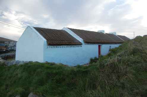 Teach MhuirisHouse · 1.4 mi
Explorer Tom Teach Mhuiris is wearing a thatched helmet held on by stone pegs and ropes. Built c.1860, I picture tugging one of…
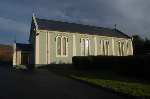 Teach Pobail Cholmcille Naofa [Saint Colmcille's Catholic Church]Church/chapel · 1.8 mi
Explorer Tom Saint Colmcille's Catholic Church in Brinlack has these zigzag Celtic chevrons staring at me from the porch window. I…
 An Trá GhealBeach / strand · 2.8 mi
Explorer Tom An Trá Gheal in County Donegal would absolutely sue the council for letting the seagulls park their junk on its…
 Inis OirthirIsland · 2.9 mi
Explorer Tom Inis Oirthir is playing hard to get from the ferry, and I bet Saint Patrick would’ve said it was too much effort for…
 An Trá LíonaBeach / strand · 3.0 mi
Explorer Tom An Trá Líona in County Donegal claims to have an identical twin beach on the other side of the ocean, but we’re all…
 Burial ground in An LuinnighBurial ground · 3.4 mi
Explorer Tom Burial ground in An Luinnigh is a bit of a mystery, with human bones popping out of a sand quarry near Gweedore. The…
 Inis MeáinIsland · 3.6 mi
Explorer Tom Inis Meáin is the Donegal island called Inishmeane, with old map spellings and even a past post office in its name…
 Magheragallon Cemetery / Machaire Gathlán GraveyardGraveyard · 4.4 mi
Explorer Tom Magheragallon Cemetery measures just 9.25m by 4.5m internally, making it a surprisingly snug little box for a sacred…
 Magheragallon CemeteryGraveyard · 4.4 mi
Explorer Tom Magheragallon Cemetery explains the 1800s to teenagers by saying it was basically just everyone waiting for better…
 Gweedore Golf ClubGolf course · 4.5 mi
More historic places in County Donegal · All of County Donegal

What do you know about this place?Tap to add a comment or ask a question