Places near here
Photo credits
- Donegal Day Out (individual photographer not stated), Donegal Day Out
- Joseph Mischyshyn, Wikimedia Commons · CC BY-SA 2.0
- Golfing in Ireland; photographer not stated, Source publisher
- Donegal Daily; original photographer not named in article, www.donegaldaily.com
- National Inventory of Architectural Heritage
- John Daye at en.wikipedia, Wikimedia Commons · CC BY-SA 3.0
- Rossographer, Wikimedia Commons
- Michael Dibb, Wikimedia Commons · CC BY-SA 2.0
- N Chadwick, Geograph · CC BY-SA 2.0
- Rossographer, Wikimedia Commons · CC BY-SA 2.0
- Kenneth Allen, Wikimedia Commons · CC BY-SA 2.0
 Portarthur, DerrybegOfficial bathing water · 844 yd
Explorer Tom Portarthur near Derrybeg looks like a small patch of sand on the map, then manages to bring an estuary, an island and a…
 Inis OirthirIsland · 1.2 mi
Explorer Tom Inis Oirthir is playing hard to get from the ferry, and I bet Saint Patrick would’ve said it was too much effort for…
 Gweedore Golf ClubGolf course · 1.6 mi
 Magheragallon, Gaoth DobhairGAA ground · 1.7 mi
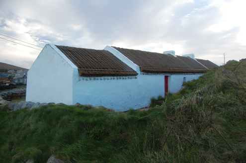 Teach MhuirisHouse · 1.9 mi
Explorer Tom Teach Mhuiris is wearing a thatched helmet held on by stone pegs and ropes. Built c.1860, I picture tugging one of…
 farmyard complex2.1 mi
Explorer Tom Farmyard complex in Gola features external steps leading directly to a first-floor gable doorway. It looks like the…
 GabhlaIsland · 2.3 mi
Explorer Tom Gabhla, or Gola Island, is close enough to the Gweedore shore for you to see where you came from and far enough away to…
 Trá Dún MórBeach / strand · 2.7 mi
Explorer Tom Trá Dún Mór sits at the northern tip of the Carrickfinn peninsula, where Donegal somehow finds room for another…
 Cnoc FolaMountain / peak · 3.0 mi
Explorer Tom Cnoc Fola is the hill above the headland, with an old tale tying its name to Balor's blood. I picture a giant needing a…
 CarrickfinnOfficial bathing water · 4.6 mi
Explorer Tom Carrickfinn lets you watch Donegal arriving by air while your feet are planted in some of its loveliest sand. A plane…
 Cairn, CronalaghtPublicly named cairn · 4.9 mi
Explorer Tom Cairn, Cronalaght is in a bitter feud with the rain because it keeps getting wet but refuses to acknowledge that it’s…
 Stone Circle near Donegal AirportPublicly named stone circle · 5.0 mi
Explorer Tom Stone Circle near Donegal Airport is sitting on the flattest patch of earth I’ve ever seen. With planes zooming…
More beaches and strands in County Donegal · All of County Donegal

What do you know about this place?Tap to add a comment or ask a question