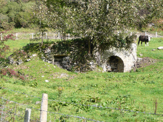
What is recorded here
Freestanding two-bay lime kiln on rectangular-plan, erected c. 1800, having square-headed aperture to the west and round-headed aperture to the east. Set into natural slope in field. Now out of use with trees growing from site. Constructed of roughly coursed rubble stone masonry and rubble stone masonry. Roughly…
Read the whole record
From the Buildings of Ireland (National Inventory of Architectural Heritage) record 40901735
Places near here
Photo credits
- National Inventory of Architectural Heritage
- Kenneth Allen, Geograph · CC BY-SA 2.0
- MPF, Wikimedia Commons · CC BY-SA 3.0
- Kenneth Allen, Wikimedia Commons · CC BY-SA 2.0
- Ronnie Nijboer, Wikimedia Commons · CC0
- Rossographer, Geograph · CC BY-SA 2.0
- Richard Webb, Wikimedia Commons · CC BY-SA 2.0
- Ben Brooksbank, Geograph · CC BY-SA 2.0
- Michael Murtagh, Geograph · CC BY-SA 2.0
- Carroll Pierce, Wikimedia Commons · CC BY-SA 2.0
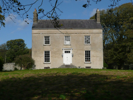 Fanad GlebeRectory/glebe/vicarage/curate's house · 685 yd
Explorer Tom Fanad Glebe was built with just one hundred pounds, which sounds like a pocketful of coins. I bet they stacked those coins so high that the walls had to lean in to keep them from bouncing away.
 walled garden712 yd
Explorer Tom Walled garden in Carrowkeel Glebe has a tiny wrought-iron flat bar gate that looks too serious for just tomatoes. I wonder if the priest had to knock three times before the door would even creak? It feels like a very strict bouncer for some radishes.
 Moross CastleCastle, tower house · 1.8 mi
Explorer Tom Moross Castle was built in 1532 and sits on a tiny rocky island connected by a causeway. By 1622, someone had slapped a thatched roof on the ruins while it lay waste, which is peak medieval DIY. Only the southwest corner survives now, but that narrow causeway makes it feel like you’re walking onto a very defensive boat.
 Hazel2.5 mi
Explorer Tom Hazel in County Donegal is playing hard to get behind some invisible fence. Rumor has it it knows where all the nuts are buried, but you'd need a lawyer to ask nicely. Send me a cheeky wave.
 Drumfad Lower Standing StoneStanding stone · 2.6 mi
Explorer Tom This standing stone in Drumfad Lower used to stand proudly on a ridge with sweeping views of Trusk More, though it did take a tumble during a storm back in 1998. After a rescue excavation to uncover its original socket pit, it was carefully re-erected so it could keep watch over the plateau.
 Wych Elm2.7 mi
Explorer Tom Wych Elm five in County Donegal is being extra dramatic about its location. It thinks it's the last one standing, which is very noble but also exhausting. Permission required for eye contact. Tell it to take a breath.
 PortsalonOfficial bathing water · 3.0 mi
Explorer Tom Portsalon runs in a wide sandy curve along Lough Swilly, with Knockalla rising behind it. I can almost see a giant pencil trying to draw that line in one stroke. That's the bit that grabs me: sand, water and mountains making one huge sweep, without needing a beauty contest to tell me so.
 Wild Atlantic Way:Ballymastocker StrandVisitor information · 3.7 mi
Explorer Tom This sign for Ballymastocker Strand sits proudly above the beach, inviting you to step off the Wild Atlantic Way and into the sand.
 Ballymastocker StrandViewpoint · 3.7 mi
Explorer Tom Ballymastocker Strand is just vibing by itself in County Donegal today. It looks like it’s waiting for a film crew that never shows up. It’s the kind of place that makes a dull Tuesday feel like a proper adventure, so don’t overthink it.
 Lighthouse TavernPub · 4.4 mi
Explorer Tom Lighthouse Tavern in County Donegal is closed on Thursdays, which means it’s perfect for mysterious disappearances. If you go Tuesday, bring a flashlight just in case.
 Knockalla FortMartello tower and coastal battery · 4.5 mi
Explorer Tom Knockalla Fort guarded the Donegal coast and Lough Swilly during the Napoleonic Wars. Its building record describes a rounded two-storey tower, a dry moat, firing holes and gun mounts on the roof. That is a lot of defence in one place. The record names five other forts nearby; I wonder how their views joined up.
 Dunree HeadHeadland · 4.9 mi
Explorer Tom Dunree Head is where the legend runs out and the map begins. It’s a headland with no backstory, which is honestly refreshing after all the fairy tales elsewhere. Bring your own legend, I've run out.
More historic places in County Donegal · All of County Donegal

What do you know about this place?Tap to add a comment or ask a question