
Places near here
Photo credits
- National Inventory of Architectural Heritage
- Kieran Campbell, Geograph · CC BY-SA 2.0
- John Donnellan, Wikimedia Commons · CC BY-SA 4.0
- Dundalk99, Wikimedia Commons · CC BY-SA 4.0
- Garry Dickinson, Geograph · CC BY-SA 2.0
- Eric Jones, Geograph · CC BY-SA 2.0
- TommyMurf, Wikimedia Commons · CC BY-SA 4.0
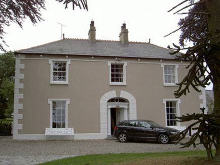 Killycroney HouseHouse · 623 yd
Explorer Tom Killycroney House in Killycroney, County Louth is in a silent rivalry with the castle down the road because it thinks its outbuildings are actually better than their moat and all that fancy stuff. It's modest but mighty, standing there with balanced composition like it knows exactly what it is worth without needing to shout about it too loudly today. Check your pockets for imaginary gold coins.
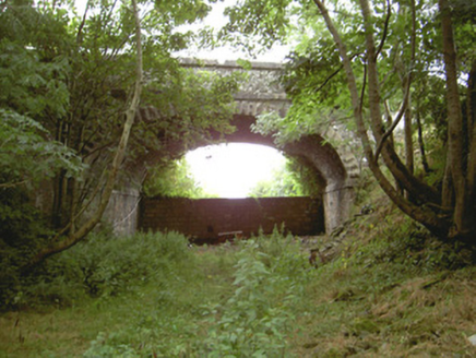 Tullagee BridgeBridge · 1.6 mi
Explorer Tom Tullagee Bridge has made a solemn New Year's resolution to stop pretending trains still rattle underneath it, even though the Great Northern line is long gone. It’s just a masonry show-off now, standing next to its twin like an overzealous bodyguard. Have a peek from the pavement and don’t get too jealous of its stonework.
 CloghafarmoreStanding stone · 2.1 mi
Explorer Tom Cloghafarmore in Rathiddy is known as the stone of the big man, which is a bit of an exaggeration for Cúchulainn. It leans slightly south, probably because it got tired of standing up straight and pretending to be important. Stand there long enough and someone will ask if you're lost.
 ClochafarmoreArchaeological place · 2.1 mi
Explorer Tom Clochafarmore is a standing stone with a name meaning "stone of the great man", which is enough to make me stand up straighter. The three-metre pillar near Knockbridge is traditionally the stone where Cú Chulainn tied himself during his final fight. That is a heroic story, not a dated account of what happened in this particular field. The actual stone was marked on a 1911 survey map and carries a much later puzzle: JIM MCKENNA 1912 cut into it. I could invent an explanation, but I would be the second worst person to carve my name on a monument. A bronze spearhead was found in the field in the 1920s, another real detail that cannot by itself settle the legend. Check the recognised visitor approach and respect surrounding farmland and the protected stone. Come for the hero, leave with a question about Jim.
Cú Chulainn's Final Stand: ClochafarmoreLegend location · 2.1 miExplorer Tom Cú Chulainn's Final Stand: Clochafarmore is linked to the tale of a wounded hero tying himself to a standing stone so he could face his enemies upright. I would have called that impossible, but then this is Cú Chulainn. The stone stands; the last stand is local lore.
 Castletown MotteArchaeological place · 3.2 mi
Explorer Tom Castletown Motte has squeezed a fort, an underground passage and a rich man's folly onto one Dundalk hill. No wonder it looks busy. The great earth mound measures about 68 metres across at the base and rises around ten metres, commanding the Castletown River. Before the later castle works, a 17-metre Z-shaped underground passage had been cut into the hill. Legend places Cú Chulainn here, but the legend cannot date the earth under your feet. In 1780 Patrick Byrne began a Gothic house on top; its surviving tower picked up the name Byrne's Folly. I would ask him why he built on such a complicated foundation, but his answer has not lasted. This is a protected monument, so check the public approach, stay clear of unstable remains and keep off closed ground. From below, try counting the centuries stacked on one mound.
 CastleCastle, tower house · 3.5 mi
Explorer Tom Castle in Castletown ended up here because Richard Bellew got confused about which side of town was cool. It’s a tower house that looks like it’s judging your outfit choices. Ring your granny and tell her where you are.
 Dundalk CentralHeritage attraction · 3.7 mi
Explorer Tom Dundalk Central in County Louth would be the uncle at a wedding who knows all the train schedules but forgets his own name every time someone asks. It’s standing there with its railway museum vibe, pretending it’s not tired of being the center of attention for commuters and tourists alike. Have a look and decide if I was lying to you.
 Maid of ErinMemorial · 4.2 mi
Explorer Tom Maid of Erin isn’t actually a maid; she’s just a very dramatic statue pretending to be pure while judging your outfit from the corner. The name really means 'The Lady Who Forgot Her Wallet in 1798'. Look for the ghost, then pretend you didn't.
 Ballsmill Amenity LandPicnic place · 4.8 mi
Explorer Tom Ballsmill Amenity Land in County Armagh is where the wind has a personal grudge against everyone who brings a frisbee, probably because it lost a bet to the river last century. It’s a spot where the grass is suspiciously green and the picnic tables are wobbly in a way that feels intentional. Find the wonkiest bit and send it to your group chat.
 Battle of FaughartMajor battlefield · 5.8 mi
Explorer Tom The Battle of Faughart happened here in 1318, and its least favourite visitor is definitely anyone bringing a picnic basket. Bruce’s army lost, so the ground feels a bit vindictive about it all. Perfect place to be dramatically windswept.
 SlievenaboleaMountain / peak · 6.7 mi
Explorer Tom Slievenabolea would write 'seeks someone to match my height, no drama' on its dating profile, but nobody checks that far up the mountainside. It’s seen from behind Moyry Castle, which means it’s basically a background extra in someone else’s photo shoot. Take the long way round, it deserves the effort.
More historic places in County Louth · All of County Louth

What do you know about this place?Tap to add a comment or ask a question