What is recorded here
Places near here
Picture notes
- National Inventory of Architectural Heritage
- John Daye at en.wikipedia, Wikimedia Commons · CC BY-SA 3.0
- Joseph Mischyshyn, Wikimedia Commons · CC BY-SA 2.0
- Computer-made picture. It does not show this playground.
- Rossographer, Geograph · CC BY-SA 2.0
- N Chadwick, Geograph · CC BY-SA 2.0
- Kieran Evans, Geograph · CC BY-SA 2.0
- louise price, Wikimedia Commons · CC BY-SA 2.0
- Kenneth Allen, Wikimedia Commons · CC BY-SA 2.0
 Inland CragCliff · 1420 yd
Explorer Tom Inland Crag might sound like something from a fantasy novel, but it’s real rock and worth finding for sure.
 farmyard complex1717 yd
Explorer Tom Farmyard complex in Gola features external steps leading directly to a first-floor gable doorway. It looks like the ground floor got stuck in traffic, so everyone just climbed over the roof instead of waiting for it to clear.
 GabhlaIsland · 1738 yd
Explorer Tom Gabhla has its old houses tucked along the sheltered east side while the western hills take the weather. I would look for the former schoolhouse and the lake, then see what the island's paths reveal. The first adventure is practical: confirm a boat before you pack.
 Inis OirthirIsland · 1.6 mi
Explorer Tom Inis Oirthir saw its population skyrocket to forty-three in 1901 before everyone quietly vanished by 1956. That is a faster exit than most office parties, don’t you think?
Portarthur, DerrybegOfficial bathing water · 2.1 miExplorer Tom Portarthur, Derrybeg, has a rocky outcrop at one end, a little estuary at the other and small islands trying to calm the Atlantic in front. That is a busy cast for one sandy beach. The sea still brings a strong wash, so I would keep the water plans tied to live local warnings.
 Children's playground3.1 miComputer-made picture. It does not show this playground.
Explorer Tom Children's playground in County Donegal is apparently just a void, which is brilliant for my imagination. I bet the swings are haunted by invisible toddlers who scream at midnight. Snap a photo of nothing if you dare!
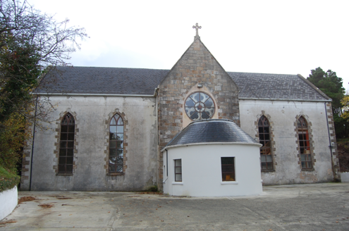 Bunbeg Community CentreChurch/chapel · 3.5 mi
Explorer Tom Bunbeg Community Centre began as a church around 1860; a rose window came with the 1874 chancel. The building survey records it as a hall now. I expected a plain hall; the rose window made me go back and read the older story.
 Cnoc FolaVisitor information · 3.9 mi
Explorer Tom Cnoc Fola, or Bloody Foreland, is a dramatic viewpoint on the Wild Atlantic Way in Donegal, steeped in legend.
 CarrickfinnOfficial bathing water · 4.2 mi
Explorer Tom Carrickfinn brought a beach and then sneaked a meadow in behind it. Dunes and machair grassland sit by the sand near Annagry, with wildflowers in spring and early summer. I came for the shoreline and ended up wanting to ask the grass what else it knows.
 Braade StrandBeach / strand · 4.4 mi
Explorer Tom Braade Strand has some water sitting behind the beach. I reckon the tide just got confused about which way is up there.
 Cliffs of OweyPublicly named cliff or headland · 4.5 mi
Explorer Tom Standing at the Cliffs of Owey feels like looking into the soul of Donegal, though access can be a bit tricky.
 Stone Circle near Donegal AirportPublicly named stone circle · 4.7 mi
Explorer Tom Stone Circle near Donegal Airport is sitting on the flattest patch of earth I’ve ever seen. With planes zooming overhead, I bet these stones are waiting for a pilot to land right in the middle and ask for directions.
More islands in County Donegal · All of County Donegal
What do you know about this place?Tap to add a comment or ask a question