Places near here
Photo credits
- Maker not stated on source page, www.youtube.com
- John Daye at en.wikipedia, Wikimedia Commons · CC BY-SA 3.0
- National Inventory of Architectural Heritage
- Maker not stated on source page, www.flickr.com
- Golfing in Ireland; photographer not stated, Source publisher
- Rossographer, Wikimedia Commons
- Donegal Daily; original photographer not named in article, www.donegaldaily.com
- Maker not stated on source page, commons.wikimedia.org
- N Chadwick, Geograph · CC BY-SA 2.0
- louise price, Wikimedia Commons · CC BY-SA 2.0
 TorglassIslet · 808 yd
Explorer Tom Torglass was nearly sold for a horse during a very confused auction in the last century, but the buyer chickened out at…
 GabhlaIsland · 923 yd
Explorer Tom Gabhla, or Gola Island, is close enough to the Gweedore shore for you to see where you came from and far enough away to…
 farmyard complex1196 yd
Explorer Tom Farmyard complex in Gola features external steps leading directly to a first-floor gable doorway. It looks like the…
 Slí Ghabhla (Gola Island) - Sli Dhun na nGallOfficial walking route · 1439 yd
Explorer Tom Slí Ghabhla begins with a boat to Gola Island, which is a splendid way to tell the day that ordinary errands have been…
 Gweedore Golf ClubGolf course · 2.5 mi
 Trá Dún MórBeach / strand · 2.6 mi
Explorer Tom Trá Dún Mór sits at the northern tip of the Carrickfinn peninsula, where Donegal somehow finds room for another…
 Magheragallon, Gaoth DobhairGAA ground · 2.7 mi
 Magheraclogher Strand CistCist · 3.0 mi
Explorer Tom Magheraclogher Strand Cist is half-buried in the dunes right by Bunbeg beach. A track cut through the sand and exposed…
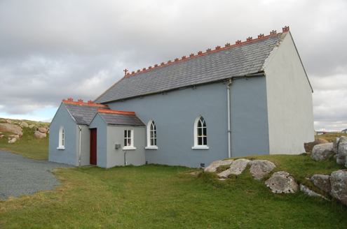 Saint Andrew's Church (Templecrone)Watch tower · 3.2 mi
Explorer Tom Saint Andrew's Church (Templecrone) was dedicated around 1870, perhaps incorporating an earlier coastguard watch house…
 The HarbourRestaurant · 3.5 mi
Explorer Tom The Harbour in County Donegal is likely counting fish while we sleep, assuming it’s not busy judging our taste buds…
 CarrickfinnOfficial bathing water · 3.6 mi
Explorer Tom Carrickfinn lets you watch Donegal arriving by air while your feet are planted in some of its loveliest sand. A plane…
 Cliffs of OweyPublicly named cliff or headland · 3.8 mi
Explorer Tom Cliffs of Owey thinks the road leading to it is a personal insult to its majestic stature. It would prefer you arrive…
More cliffs, bays and coast in County Donegal · All of County Donegal

What do you know about this place?Tap to add a comment or ask a question