Places near here
Photo credits
- Wanfried-Dublin, Wikimedia Commons · CC BY-SA 4.0
- National Inventory of Architectural Heritage
- Colette Gemmell, Wikimedia Commons · CC BY-SA 4.0
- Oliver Dixon, Geograph · CC BY-SA 2.0
- JP, Wikimedia Commons · CC BY-SA 2.0
- Stephan van Helden, Wikimedia Commons · CC BY-SA 4.0
- Kevgorman, Wikimedia Commons · CC BY-SA 4.0
 Portal tomb in ErveyPortal tomb · 546 yd
Explorer Tom Portal tomb in Ervey is sitting pretty on that little col, looking like it just woke up from a nap. That massive roofstone? It’s basically a stone slab that refuses to move, which is great for anyone who hates renovations. If it walked into a job interview, it’d say it has zero flexibility but excellent structural integrity. A proper spot for a flask of tea and a big think.
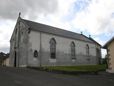 Our Lady of Mount CarmelChurch/chapel · 2.0 mi
Explorer Tom Our Lady of Mount Carmel is showing off its 1858 muscles because it replaced an older church from 1787. It’s got that fancy tower-like breakfront thing, which sounds like a muscle car. Take a selfie with it before it starts charging admission.
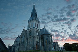 Church of the Immaculate ConceptionChurch/chapel · 2.1 mi
Explorer Tom Church of the Immaculate Conception in Dunaree is showing off its Victorian Gothic stonework like it’s trying to win a beauty pageant for churches. It’s got that alternating slate and stone look that makes it pop against the sky. Your move: go take a look and see if you can handle all that stonework finesse!
Castle in ruinsCastle, unclassified · 2.3 miExplorer Tom Castle in ruins in Cordoagh is suspicious of the postman, so it never gets any letters. It’s just a hole in the ground pretending to be a fortress, which is basically my personality on Mondays. Bring a map, get lost anyway, that's the fun.
 Fair of MuffMemorial · 2.4 mi
Explorer Tom Fair of Muff is sick of being asked if it’s still selling horses when it’s mostly just remembering how to do it properly now. Spot the oldest stone and give it a name; I bet it has a better story than most people in town anyway.
CabraMountain / peak · 2.9 miExplorer Tom Cabra gave up chocolate for Lent last year but kept stealing biscuits from the neighbours' plates, which explains why it looks so round and happy despite its fasting claims. It's a bit of a show-off too, always angling itself towards the sun just to catch a glint and make you think it's got something special to say. Stand on the spot and imagine the gossip it's heard.
 Dún a Rí Forest ParkForest · 3.1 mi
Explorer Tom Dún a Rí Forest Park is the site of a fierce feud between two families over who owns the view from the top. They’re still screaming about it. A proper spot for a flask of tea and a big think.
Castle ruinsCastle, unclassified · 3.2 miExplorer Tom Cabra Castle ruins would tell their younger self: 'You built two gates, we only have vibes'. It was a big castle in the 1600s, now it’s a stone skeleton with style. Best visited with a curious kid and no timetable.
 Horse-chestnut3.2 mi
Explorer Tom Horse-chestnut in County Cavan witnessed a love story that went badly wrong right next to it; someone threw a hat at it in anger. It’s still processing the trauma. Bring a coin for luck and keep it in your pocket so you don't lose it like they did their heart.
In Memory of Our DadMemorial · 3.2 miExplorer Tom The memorial for Our Dad here claims a fiddler played so loudly one night that the stones actually vibrated into a new shape. It’s a tall tale, but it fits the vibe of this very serious-looking spot in the middle of nowhere. Ideal spot for a dramatic phone call.
TeevurcherMountain / peak · 3.5 miExplorer Tom Teevurcher would be the uncle at a wedding who stands in the corner holding a drink and judging everyone’s dancing. It has that energy of 'I’m here, but I’m not really involved' that you can’t quite shake off. I bet it’s secretly enjoying watching the chaos from its high vantage point. Bring a coin for luck and keep it in your pocket.
 Grave YardGraveyard · 4.7 mi
Explorer Tom Graveyard in Relagh Beg is walled off like it's protecting a state secret. The gate has a date on it, but I'd bet good money it's wrong. It's the kind of place that makes a dull Tuesday interesting, trust me.
More archaeology and monuments in County Meath · All of County Meath

What do you know about this place?Tap to add a comment or ask a question