What is recorded here
Located on a bluff overlooking a small W-E valley. Tomhaggard is not listed in a survey of Catholic priests in Ferns diocese in 1731 (Anon. 1915, 166-9), but Jasper Devereux was registered as the pastor of Mayglass and Tomhaggard in 1703 (Grattan Flood 1915, 68). The structure is marked on the 1839 ed. of the OS…
Read the whole record
Located on a bluff overlooking a small W-E valley. Tomhaggard is not listed in a survey of Catholic priests in Ferns diocese in 1731 (Anon. 1915, 166-9), but Jasper Devereux was registered as the pastor of Mayglass and Tomhaggard in 1703 (Grattan Flood 1915, 68). The structure is marked on the 1839 ed. of the OS 6-inch map but it is not named. This is a stone walled thatched structure (ext. dims. 7.1m NW-SE; 5.5m NE-SW; int. dims 5.9m NW-SE; 3.7m NE-SW) built against the inner face of the SE wall of the tower house (WX047-050002-), probably at the first floor level. A window embrasure has been blocked at the bottom creating an altar shelf (Wth 1.73m; H 1.14m; D 0.53m). There is no evidence of an enclosure or burial associated with it, but there is a D-shaped stone (dims 0.5m x 0.28m) over the doorway carved with four curves on its rounded edge and a T-shaped incision. St James' Well (WX047-049----) is c. 35m to the W and St Anne's Well (WX047-051----) is c. 10m to the N at the base of the bluff. A small excavation (03E0646) connected with the underpinning of a buttress on the N side of the mass-house failed to produce any related material (Hayden 2006).
From the National Monuments Service (Archaeological Survey of Ireland) record WX047-050001
Places near here
Picture notes
- National Inventory of Architectural Heritage
- Computer-made picture. It does not show this holy well.
- Computer-made picture. It does not show this monument.
- Mike Searle, Wikimedia Commons · CC BY-SA 2.0
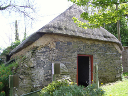 church/chapel2 yd
 St. Annes WellHoly well · 6 ydComputer-made picture
 St. Anne's GrottoWayside shrine · 23 ydComputer-made picture
 water pump53 yd1798 Memorial PlaqueMemorial · 54 ydCastleCastle, tower house · 790 ydThe Bull RockForest · 923 ydThe Heron's MeadowForest · 1197 ydThe White Hole BeachBeach / strand · 1.7 miThe HamBay · 1.7 mi
_-_geograph.org.uk_-_3715787.jpg/250px-Castles_of_Leinster,_Ballyhealy,_Wexford_(1)_-_geograph.org.uk_-_3715787.jpg "Photo: Mike Searle, Wikimedia Commons · CC BY-SA 2.0") Castle (in ruins)Castle, tower house · 2.2 miBallyhealy BeachBeach / strand · 2.3 mi
Castle (in ruins)Castle, tower house · 2.2 miBallyhealy BeachBeach / strand · 2.3 miMore historic places in County Wexford · All of County Wexford

What do you know about this place?Tap to add a comment or ask a question