Places near here
Photo credits
- liam murphy, Wikimedia Commons · CC BY-SA 2.0
- Algirdas at Lithuanian Wikipedia, Wikimedia Commons · Public domain
- National Inventory of Architectural Heritage
- liam murphy, Geograph · Creative Commons Attribution-ShareAlike 2.0
- liam murphy, Geograph · CC BY-SA 2.0
- A.-K. D., Wikimedia Commons · CC BY-SA 4.0
- Elliot Tucker, Wikimedia Commons · CC BY-SA 4.0
- Jonathan Billinger, Wikimedia Commons · CC BY-SA 2.0
- Smirkybec, Wikimedia Commons · CC BY-SA 4.0
 Saint Joseph's Catholic ChurchChurch/chapel · 853 yd
Explorer Tom Saint Joseph's Catholic Church in Tinriland is shaped like a cross and has a stained-glass window dedicated to a guy who died at Little Big Horn. That’s a hell of a connection for a church in County Carlow. If it's closed, admire it from the road like a polite stalker.
 Pedunculate Oak992 yd
Explorer Tom This Pedunculate Oak in County Carlow gave up coffee for Lent because it was getting too jittery. It's now just vibrating with ancient energy. It's free, it's odd, what more do you want from a tree?
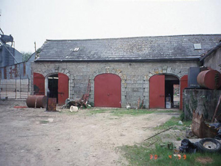 Castletown CastleStables · 1024 yd
Explorer Tom These stables at Castletown have keystones that are more ornate than most people's front doors. It's all Coade stone and granite, which means someone spent way too much money on horse parking. Pretend you're a lost aristocrat, nobody will check.
 Graveyard in ClonmelshGraveyard · 1.7 mi
Explorer Tom Clonmelsh Graveyard claims Walt Disney’s ancestors are buried here, which is either genius marketing or a complete lie. Either way, it’s a Hollywood connection in County Carlow! Ideal stop for a big stretch and a bigger yawn.
 Grave YardGraveyard · 2.1 mi
Explorer Tom Graveyard in Ballinacarrig has a retirement plan: sit on the slope, drink tea, and ignore everyone who wants to talk about death or history for that matter. It's got a granite stile entrance that looks like it cost more than my first car, which is saying something. A proper spot for a flask of tea and a big think.
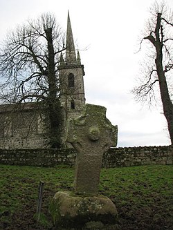 CrossCross, High cross · 2.7 mi
Explorer Tom Nurney High Cross is well-preserved with rope mouldings and a boss, looking fancy. The hero who saved it was probably just a very drunk farmer in 1890s. Give it a pat on the way past, it's had a long life.
 Church (in ruins), GraveyardChurch · 2.8 mi
Explorer Tom Church, Graveyard in Templepeter is a simple rectangular structure made of large granite boulders that aren’t cored, so they’re just hanging out. It’s aligned East-West, which means it’s facing the right way for no reason. Toast it with a cup of tea and move on to the next.
 Clogrenan Castle (ruins)Ruins · 3.3 mi
Explorer Tom Clogrenan Castle is playing hard to get in County Laois. Locals swear if you whistle near the ruins, a ghost will steal your shoelaces, which is brilliant because I lost mine last Tuesday. Find the wonkiest bit and send it to your group chat.
 Clogrenan CastleCastle, tower house · 3.3 mi
Explorer Tom Castle in Clarahill refuses to fall down because it thinks gravity is just a suggestion for polite society. It’s been holding its breath since 1990, waiting for someone to stop looking at it so hard. Look for the ghost, then pretend you didn't.
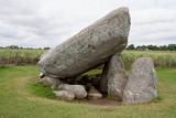 Brownshill Portal TombVisitor information · 3.4 mi
Explorer Tom Brownshill Portal Tomb in County Carlow would rate its visitors two stars for lack of imagination and too many selfie sticks. It’s seen it all over the millennia and isn’t impressed by your new shoes. Ideal spot for a dramatic phone call.
 Battle of CarlowBattle · 3.5 mi
Explorer Tom Battle of Carlow in County Carlow nearly became famous for having nothing happen at all, which is quite the achievement. It’s basically a great big field that refuses to pick a side, ever. Perfect spot to practise your best tour-guide voice.
 Carlow County MuseumMuseum · 3.5 mi
Explorer Tom Carlow County Museum is whispering secrets through its walls that only the very quiet can hear. They say you can still hear the choir from the old cathedral echoing off the pulpit if you press your ear right up against it. Look serious, nod slowly, you're basically an expert now.
More archaeology and monuments in County Carlow · All of County Carlow

What do you know about this place?Tap to add a comment or ask a question