
Places near here
Photo credits
- National Inventory of Architectural Heritage
- Hywel Williams, Geograph · CC BY-SA 2.0
- Neville Goodman, Wikimedia Commons · CC BY-SA 2.0
- Neville Goodman, Geograph · Creative Commons Attribution-ShareAlike 2.0
- Algirdas at Lithuanian Wikipedia, Wikimedia Commons · Public domain
- Mike Searle, Wikimedia Commons · CC BY-SA 2.0
Explorer Tom Graveyard in Kilnagnady is playing hard to get because it’s basically a field with a secret past. Fences are gone, ground’s flat, and the locals say it’s attached to a church that vanished like my motivation. Perfect detour when your GPS thinks you’re on the moon.
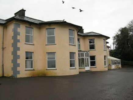 Upton HouseCountry house · 1606 yd
Explorer Tom Upton House in Garryhankard is a fine Georgian country house from c.1780. It’s got those full-height bows and recessed wings creating an undulating front. Classical geometry at its best! The entrance porch looks very official.
 Eastern LodgeGate lodge · 1689 yd
Explorer Tom Eastern Lodge in Garryhankard was built around 1860 to show off Upton House’s wealth. It’s got ornate piers and caps that were clearly crafted by people who really knew what they were doing with cast iron.
 BeechmountCountry house · 1740 yd
Explorer Tom Beechmount is a substantial country house on an elevated site that creates a striking impression in its open rural surrounds. It’s got sash windows and render detailing that make it look like it’s posing for photos constantly. Take a breath, because it’s about to demand your attention and a small fee.
 Ballinacurra MillMill (water) · 1.1 mi
Explorer Tom Ballinacurra Mill in Kilmore is still spinning its wheels while everyone else drives past. It formed the centre of a massive industrial complex, so basically it was the boss of all the flour and grain back then. Handsome roadside feature if you like looking at bricks.
 Grave YardGraveyard · 1.2 mi
Explorer Tom Graveyard in Kill has high stone walls and headstones from 1795, plus some rounds paid at a specific grave. It’s atop a hill with a church ruin just north of center. Make sure you tip your hat to Rev. Patrick Murphy!
 Sunday WellSpring · 1.3 mi
Explorer Tom This Sunday Well has a ghost that’s too lazy to haunt it properly; he just sits there looking bored and judging your footwear. It’s the laziest supernatural presence in County Cork. Bring curiosity, leave with a better story than mine.
Ballyhandle Castle (in Ruins)Castle, Anglo-Norman masonry castle · 1.9 miExplorer Tom Ballyhandle Castle has a favourite song called 'Mason’s Lament' and it plays on loop in my head. It’s got that 'I’m older than you think' vibe despite being half-demolished. Stop the car, it’s worth the hazard lights and the gossip.
Dromkeen WoodWood · 3.2 miExplorer Tom Dromkeen Wood ended up here because someone took a wrong turn on purpose and decided to stay. It’s got that accidental charm that you just have to accept as part of the deal. Go on, count the windows and get it wrong like I did.
 Kilpadder Burial Ground (Site of)Burial ground · 4.0 mi
Explorer Tom Kilpadder Burial Ground is hiding in the pasture so deep it refuses to fall down or get found. The overgrowth is basically doing a great job of keeping secrets. Bring a jacket, it's never as warm as I promise.
 Pedunculate Oak5.3 mi
Explorer Tom Another Pedunculate Oak in County Cork is hiding a scandal from centuries ago that involved a missing hat and a very angry bishop. No proof, just vibes. Perfect place to be dramatically windswept and ignore the wind.
 Castlemore CastleCastle · 5.7 mi
Explorer Tom Castlemore Castle in County Cork is run by a dog who thinks he's the owner. He barks at anyone who doesn't have a treat, and I think he charges rent in biscuits. It’s a very strict regime, but the castle looks well-kept because of it. Hang around long enough and you'll hear a story from a local.
More archaeology and monuments in County Cork · All of County Cork

What do you know about this place?Tap to add a comment or ask a question