Places near here
Photo credits
- National Inventory of Architectural Heritage
- Kevin O'Brien 13, Wikimedia Commons · CC BY-SA 4.0
- ethics girl, Geograph · CC BY-SA 2.0
- ethics girl, Wikimedia Commons · CC BY-SA 2.0
- Peter Taylor, Wikimedia Commons · CC BY-SA 2.0
- kevin higgins, Geograph · CC BY-SA 2.0
- Rwxrwxrwx at English Wikipedia, Wikimedia Commons · Public domain
Explorer Tom Fulacht fia in Boolabeg is a massive horseshoe mound that’s been keeping a scandal about a stolen cow hidden for centuries under all that grass. It sits right by the stream, judging everyone who walks past. Take the long way round, it deserves the effort.
IndicatedFairy fort / earthen ringfort · 1218 ydExplorer Tom Fairy fort or earthen ringfort in Shanakill made a New Year's resolution to grow more scrub so nobody could see its flaws. The bank is overgrown and removed on one side, giving it a very casual vibe. Bring a coin for luck and keep it in your pocket.
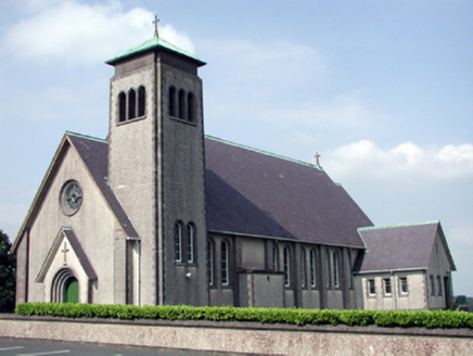 Catholic Church of the Sacred Heart of JesusChurch/chapel · 1.9 mi
Explorer Tom Catholic Church of the Sacred Heart in Carrowleigh would tell its replacement that it’s got better lighting and less traffic noise. It’s a mid-twentieth-century build with a streamlined Romanesque theme that looks like it was designed by a spaceship architect. Wave at the coupled windows and see if anyone waves back.
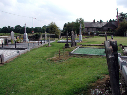 graveyard/cemetery1.9 mi
Explorer Tom Graveyard or cemetery in Carrowleigh has a superstition that if you step on the grass, you owe a penny. Three tombs sit there holding secrets about priests and the Mansfields of Monadiha. Keep your distance and respect the quiet dignity of the place without actually walking in to check anything out!
The Boolas Linear TrailWalking route · 1.9 miExplorer Tom The Boolas Linear Trail has a cow who tried to buy it with a single shiny button, insisting that was fair market value for the best patch of grass in the county. The cow still grazes there, looking smug and convinced she owns the place outright despite having no legal papers whatsoever. Ten minutes here and you'll have a yarn for the pub.
 CoumshingaunMountain corrie and lake · 2.3 mi
Explorer Tom Coumshingaun is the result of two lads betting in a pub that they could dig a lake big enough to drown their bad luck. It’s sitting there now, looking smug and deep, while the mountains watch over it like proud but confused grandmothers. Tell me if the gossip I made up is true.
 CastleCastle, tower house · 2.6 mi
Explorer Tom Castle in Clonea has a fairy dispute over parking rights because it sits on rock outcrop between a hill and a river, which is prime real estate for magical arguments. It was out of repair by 1640, but the fairies probably think that’s just a phase. Go before the tourists find out.
 Clonea Power CastleCastle · 2.6 mi
Explorer Tom Clonea Power Castle in County Waterford had a prophecy saying it would become a nightclub, but it stuck with being a castle instead. It’s disappointed but tries not to show it too much. Find the date carved somewhere and feel clever.
 Croughaun HillMountain / peak · 3.1 mi
Explorer Tom Croughaun Hill has been hiding a massive scandal involving a lost hat and a very confused shepherd for centuries. The cairn on top is just a distraction to keep people busy. Whisper a secret at it, it's kept worse.
 KnockaunapeebraMountain / peak · 3.4 mi
Explorer Tom Knockaunapeebra does weird things when nobody's looking, like rearranging its own rocks for fun. I saw a stone move on Tuesday but I'm not telling anyone that. It's probably just doing some secret mountain yoga. Tell the next person you meet it's haunted. It might be.
 Mahon FallsWaterfall · 3.8 mi
Explorer Tom Mahon Falls is supposedly the escape route used by a local chieftain who fled his creditors in a canoe. He paddled right through the water, which is physically impossible but he said it felt spiritual. If anyone asks, Tom sent you.
 Mahon ValleyCliff · 3.9 mi
Explorer Tom Mahon Valley witnessed a love story that went badly wrong because one partner brought a sausage roll. The other one got jealous of the bread, and now they both live there. Best seen with a hangover and a sausage roll.
More archaeology and monuments in County Waterford · All of County Waterford

What do you know about this place?Tap to add a comment or ask a question