
What is recorded here
Situated on rock outcrop between Croughaun Hill c. 2.5km to the S and the SW-NE Clodiagh River c. 500m to the N. It is described as 'out of repair' and the property of Lord John Power of Curraghmore (WA008-005001-) c. 1640 (Simington 1942, 108). In 1697 it was leased by James Wall of Coolnamuck, but it passed by marriage to George Morris of Waterford city at the end of the 18th century. It was disposed of in the Encumbered Estates in 1850, (Nolan 1987). This is a rectangular tower (ext. dims. 14.5m N-S; 11.1m E-W) of which the N and E walls survive complete with the adjacent parts of the W and S walls. It comprises six storeys including an attic over the third floor and two barrel-vaulted, N-S lofts; one over the ground floor, the other over the first floor. There are cut-stone quoins and a base-batter on the N wall and a large garderobe chute exits at the base of the N wall, at the E end. A destroyed entrance towards the E end of the S wall, possibly protected by a yett, led through a lobby and an inner pointed doorway to the ground floor, which had at least three embrasures, but no original features survive. A pointed doorway from the lobby leads to a newel staircase (destroyed) at the SE angle which gave access to the upper floors. A pointed doorway also leads from the stairs to the ground-floor loft which has a window (destroyed) with seats in the N wall, and the overhead vault has traces of three, possibly four, small rectangular openings penetrating to the first floor. A pointed doorway leads from the stairs to the first-floor chamber which has a destroyed window in the E wall and the remains of mural chambers in the W and S walls. The loft over the first floor is entered by a pointed doorway from the stairs. The loft has a destroyed window in the N wall and the remains of mural chambers in the W and S walls. The second floor has destroyed windows in the N and E walls, a mural chamber in the E wall and an attic overhead with the pitch of the gable roof visible in the N wall. Traces of a wall-walk on the E wall and a look-out at the SE angle survive. The tower house is enclosed by a fosse (Wth c. 8m; D c. 1m) around the base of the rock outcrop SE-W. A bawn (dims. 30m N-S; 28m E-W) to the N is defined by a bank (Wth 2-3m; H 0.3-0.6m) at W, with traces of a stone wall (Wth 0.9m) at E and a scarp at N. The foundations of some houses, probably modern, survive inside the bawn. Two towers were associated with the bawn (Ryland 1824, 299-300), although only a fragment of one remains W of the tower house. Nolan, T. (1987) The castle at Clonea-Power. Decies, No. 35, 19-23. Ryland, Rev. R. H. (1824) The History, topography and antiquities of the county and city of Waterford. John Murray. London. Simington, R. C. (ed.) (1942) The Civil Survey AD 1654-1656, vi, the County of Waterford. Irish Manuscripts Commission. Dublin.
Situated on rock outcrop between Croughaun Hill c. 2.5km to the S and the SW-NE Clodiagh River c. 500m to the N. It is described as 'out of repair' and the property of Lord John Power of Curraghmore (WA008-005001-) c. 1640 (Simington 1942, 108). In 1697 it was leased by James Wall of Coolnamuck, but it passed by marriage to George Morris of Waterford city at the end of the 18th century. It was disposed of in the…
From the National Monuments Service (Archaeological Survey of Ireland) record WA007-021001
The monument record does not grant public access. Check the route and ask the landowner before entering private land.
- What survives
- Recorded monument
Places near here
Settlement cluster in Robertstown (decies Without Drum By., Rossduff Par.)Settlement cluster · 529 yd post box725 ydClonea BridgeOfficially recorded historic building · 790 ydCroughaun HillMountain / peak · 1.5 miGiant Sequoia3.4 miJapanese cedar3.5 miCurraghmore HouseCastle · 3.6 miCoumshingaunMountain corrie and lake · 4.0 miCoolnamuck Castle (in Ruins)Castle, tower house · 5.1 miKnockaunapeebraMountain / peak · 5.1 miMahon FallsWaterfall · 5.3 miMahon ValleyCliff · 5.4 mi
 post box725 yd
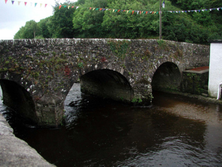 Clonea BridgeOfficially recorded historic building · 790 yd
 Croughaun HillMountain / peak · 1.5 mi
 Giant Sequoia3.4 mi
 Japanese cedar3.5 mi
 Curraghmore HouseCastle · 3.6 mi
 CoumshingaunMountain corrie and lake · 4.0 mi
 Coolnamuck Castle (in Ruins)Castle, tower house · 5.1 mi
 KnockaunapeebraMountain / peak · 5.1 mi
 Mahon FallsWaterfall · 5.3 mi
 Mahon ValleyCliff · 5.4 mi
Pictures: National Inventory of Architectural Heritage; Peter Taylor, Wikimedia Commons · CC BY-SA 2.0; Mike Murphy ( talk · contribs ), Wikimedia Commons · CC BY-SA 3.0; Yosemite, Wikimedia Commons · CC BY-SA 3.0; MainlyTwelve, Wikimedia Commons · CC BY-SA 4.0; Kevin O'Brien 13, Wikimedia Commons · CC BY-SA 4.0; John M, Geograph · CC BY-SA 2.0; kevin higgins, Geograph · CC BY-SA 2.0; Rwxrwxrwx at English Wikipedia, Wikimedia Commons · Public domain
More castles and forts in County Waterford · All of County Waterford
What do you know about this place?