
Places near here
Photo credits
- National Inventory of Architectural Heritage
- Nigel Thompson, Geograph · Creative Commons Attribution-ShareAlike 2.0
- Leomyhero at English Wikipedia, Wikimedia Commons · CC BY-SA 3.0
- Roger Diel, Geograph · CC BY-SA 2.0
- Dr Charles Nelson, Wikimedia Commons · CC BY-SA 2.0
- Andreas F. Borchert, Wikimedia Commons · CC BY-SA 4.0
- Humphrey Bolton, Geograph · CC BY-SA 2.0
- John M, Geograph · CC BY-SA 2.0
- Robert Bone, Geograph · CC BY-SA 2.0
- Paul Woods, Wikimedia Commons · CC BY 2.0
- The Banner, Wikimedia Commons · CC BY-SA 3.0
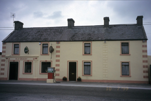 M. O'GradyHouse · 536 yd
Explorer Tom M. O'Grady in Carrowcraheen is a house that used to be a post office, which means it knows where all your letters went. Built around 1890, it’s now a pub, so the mail has been replaced by pints. Linger, it's not going anywhere and neither should you.
 Tubber Railway StationRailway station · 774 yd
Explorer Tom Tubber Railway Station in Rathwilladoon is proud of its timber sign even though no trains have come for ages. It’s been reused as a home, but it still pretends to be waiting for passengers. Bring your own nostalgia, because the seat for waiting is definitely still there, just dusty.
.JPG/250px-Fiddaun_(01).JPG "Photo: Leomyhero at English Wikipedia, Wikimedia Commons · CC BY-SA 3.0") Fiddaun Castle (in ruins)Castle, tower house · 1723 yd
Fiddaun Castle (in ruins)Castle, tower house · 1723 ydExplorer Tom Fiddaun Castle hosted a dance that went way too far, ending in a six-storey tower house being partially restored because someone spilled wine on the bogland. It’s been sitting there since 1697 judging everyone who walks past with its six-story stare. Grand place for a sulk or a snog, your call.
 Kilkeedy Castle (in ruins)Castle, tower house · 2.3 mi
Explorer Tom Kilkeedy Castle was taken by the English after a rebellion, so it’s still salty about it all these centuries later. It hears everything through its ruined walls. A handy spot to stretch your legs and your imagination.
 Cloghans or Round TowerRound tower · 3.5 mi
Explorer Tom Cloghans or Round Tower in Kilmacduagh holds the fake world record for being breached on the SW side and looking totally fine about it. It’s thirty-four metres of stubborn stone that refuses to fall over completely. Bring a map, get lost anyway, that's the fun.
 Grave YardGraveyard · 3.5 mi
Explorer Tom Graveyard in Kilmacduagh is probably complaining to the council about the lack of proper signage and the damp getting into its bones. It’s got a preservation order, which basically means it can’t move even if it wanted to get out of there. Bring a notebook and write the bit I made up.
 Kilmacduagh MonasteryHeritage attraction · 3.6 mi
Explorer Tom Kilmacduagh gives you a round tower and a name that has outlived several different churches. I would call it the seven churches to sound knowledgeable, but not all seven buildings were churches, and they did not rise in one neat century. Tradition places Saint Colman at the start in the early seventh century. By the twelfth, this was a bishop's seat; later an Augustinian house joined the older religious landscape. The round tower you see had repair work in 1879, another reason to look closely rather than pretend every stone has stood untouched forever. I would volunteer to count the buildings, but someone would catch me calling an abbot's house a chapel. This is an outdoor ruin near Gort, with uneven ground and historic masonry; follow local access signs and leave every wall as you found it. Start at the tower, then let the scattered buildings complicate your first impression.
 Kilmacduagh Monastic SiteVisitor information · 3.6 mi
Explorer Tom Kilmacduagh Monastic Site thinks Dublin tourists are basically overgrown children who need a stern lecture about history and manners. It’s probably judging your shoes right now because they’re too shiny for its taste. It's free, it's odd, what more do you want?
Swan IslandIsland · 3.8 miExplorer Tom Swan Island would tell its younger self to stop trying so hard to be elegant and just enjoy being a lumpy rock in the mud. It’s been overthinking its posture for centuries now, which is exhausting to watch. Hum something sad nearby, it adds atmosphere.
 Slieve RoeMountain / peak · 4.8 mi
Explorer Tom Slieve Roe is currently locked in a bitter feud with Slieve Elva over who has the better view of Travaun Lough, and frankly, the mountain is too busy arguing to notice you standing there looking lost. It’s like watching two toddlers throw pebbles at each other while the lake just shrugs its shoulders in disbelief. Hang around long enough and you'll hear a story from a local.
 Mullagh MoreMountain / peak · 4.9 mi
Explorer Tom Mullaghmore looks as if the Burren folded a stone tablecloth and forgot to flatten it. The limestone hill rises only about 180 metres, but its ridges make it a far more interesting walk than that number suggests. A marked loop takes you into the national park landscape. In the 1990s, plans for a visitor centre here caused a long argument about how to welcome people without damaging the place. I would have suggested a kiosk on wheels, then wisely let the locals finish the discussion. The hill itself remains the main attraction. Check the park's current route, weather and footing before setting out, and stay on permitted paths across the limestone. Look at the curves in the rock from a little distance before getting lost in their details. Mullaghmore has no need for a building to explain itself.
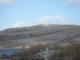 Burren National ParkNature reserve · 5.3 mi
Explorer Tom The Burren National Park is Ireland's smallest national park, and it still gives you 1,500 hectares in which to lose an argument about which way to walk. Opened to the public in 1991, it protects part of Clare's limestone country. The rock may look bare from a distance; closer in, bog, heath, grassland and woodland all ask for your attention. I would claim to know every crack in the limestone, but I would need several lifetimes and better knees. This is a living landscape, so stay on marked public routes and avoid damaging plants or crossing closed ground. Check the park's current trail advice and weather before you set out; smooth stone can turn slippery. Give yourself time to look down as well as out. The Burren is very good at making a seemingly empty patch of ground prove you wrong.
More archaeology and monuments in County Galway · All of County Galway

What do you know about this place?Tap to add a comment or ask a question