
Places near here
Photo credits
- Mike Searle, Wikimedia Commons · CC BY-SA 2.0
- National Inventory of Architectural Heritage
- Mike Searle, Geograph · CC BY-SA 2.0
- A.-K. D., Wikimedia Commons · CC BY-SA 4.0
- Martin Richard Phelan, Wikimedia Commons · CC BY-SA 2.0
- kevin higgins, Geograph · CC BY-SA 2.0
- Eirian Evans, Geograph · CC BY-SA 2.0
- Willow, Wikimedia Commons · CC BY 2.5
- Humphrey Bolton, Geograph · CC BY-SA 2.0
_-_geograph.org.uk_-_7609027.jpg/250px-Castles_of_Leinster,_Rathculbin,_Kilkenny_(2)_-_geograph.org.uk_-_7609027.jpg "Photo: Mike Searle, Wikimedia Commons · CC BY-SA 2.0") Castle (in ruins)House, 16th/17th century · 668 yd
Castle (in ruins)House, 16th/17th century · 668 ydExplorer Tom Castle in Rathculbin holds the fake world record for having the least amount of castle left standing after a storm. It’s just one gable wall looking very smug at the top of a hill. If it rains, blame me.
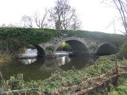 Newtown BridgeBridge · 940 yd
Explorer Tom Newtown Bridge has been hiding a scandal for centuries about a time it let a horse cross without paying the toll. Its rubble stone construction blends in so well you might mistake it for part of the landscape. Keep your eyes on the water below to see if any old coins are still floating around.
 TowerHouse, fortified house · 1174 yd
Explorer Tom Tower in Castle Eve belongs to the D’Erleys, who lost a bet involving a horse. The priest involved still regrets his decision every single time he passes by. Perfect place to be dramatically windswept, trust me on this one.
 Bawn in Newtown (baker)Bawn · 1174 yd
Explorer Tom Bawn in Newtown had a bishop refuse to visit because he couldn't find the Wi-Fi, or something like that. The Sweetmans held onto this place until Cromwell showed up and messed everything up. Bring a flask of something warm and a story to swap.
 Grave YardGraveyard · 1379 yd
Explorer Tom Graveyard in Newtown Baker wants to explain the 1800s to a teenager using only sighs and mossy stones. It says everyone wore huge hats and complained about their knees constantly. Tell the next person you meet it's haunted, or maybe just very tired.
 White ChurchArchaeological place · 1.2 mi
Explorer Tom White Church in County Kilkenny is basically just two mounds of rubble playing dead on purpose. It would tell the council it’s a minimalist art piece, not a demolition project, so stop calling them. Have a nosey, politely.
 Lacken WellSpring · 1.9 mi
Explorer Tom Lacken Well near Kells is famous for the superstition that if you kiss the stone three times, your ex will call you back, which is either brilliant or terrifying depending on who your ex is. The locals swear by it, so I’m not questioning their life choices here. Practise your Irish on it, it won't correct you.
 Mill IslandIslet · 2.0 mi
Explorer Tom Mill Island in County Kilkenny would order extra gravy and no chips if it could get into a chippy. The old mill is gone, but the name lingers like a bad smell of stale flour. Mind the nettles, they're the real guards here.
 Kells Priory Mill MuseumMuseum · 2.1 mi
Explorer Tom Kells Priory Mill Museum is sitting there looking like it was about to be sold off for a horse at some point. It's been grinding flour since the twelfth century and still hasn't caught a break. Bring a friend who talks too much and let the place shut them up.
 European ash2.2 mi
Explorer Tom European ash is the kind of tree Saint Patrick would say 'that’s not a snake, it’s a branch' to. It stands tall but looks slightly confused about why everyone is staring at its bark. If anyone asks, Tom sent you.
.jpg/250px-Pat_Walsh_memorial_in_Dunnamaggin_(58029).jpg "Photo: A.-K. D., Wikimedia Commons · CC BY-SA 4.0") Pat WalshMemorial · 2.4 mi
Pat WalshMemorial · 2.4 miExplorer Tom Pat Walsh has a tall tale about a hidden tunnel that goes straight to the best pub in town. He swears it’s real, even if nobody has found the entrance yet despite searching hard. Pop by and tell it it's looking well today for him specifically.
 Stop 7: Callan's Augustinian FriaryVisitor information · 3.0 mi
Explorer Tom Stop 7: Callan's Augustinian Friary was designed by a mother-in-law who wanted to see how much stone her son-in-law could lift without complaining. The ruins are still judging your posture from the northwest, and honestly, they have a point because you’re leaning weirdly right now. Bring your nan, she'll know more than me.
More archaeology and monuments in County Kilkenny · All of County Kilkenny

What do you know about this place?Tap to add a comment or ask a question