
Places near here
Photo credits
- Enda O Flaherty, Geograph · CC BY-SA 2.0
- National Inventory of Architectural Heritage
- Sheila1988 / Wikimedia Commons, commons.wikimedia.org
- Maelor at English Wikipedia, Wikimedia Commons · Public domain
- Andreas F. Borchert, Wikimedia Commons · CC BY-SA 4.0
- Golfing in Ireland; photographer not stated, Source publisher
- Malene Thyssen, Wikimedia Commons · CC BY-SA 3.0
- Djm-leighpark, Wikimedia Commons · CC BY-SA 4.0
- Bob Embleton, Wikimedia Commons · CC BY-SA 2.0
 The GlenWood · 825 yd
Explorer Tom The Glen in County Sligo is where the seagulls hold their weekly board meetings about how to annoy the tourists most…
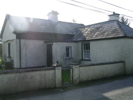 LisheenGate lodge · 1233 yd
Explorer Tom Lisheen gate lodge hosted a dance once that went so far that the slate roof started sliding off and the sash windows…
 Ransboro Park, Coolera/StrandhillGAA ground · 1263 yd
 Miosgan MevaPassage tomb · 1605 yd
Explorer Tom Miosgan Meva is the big brother on Knocknarea, sitting there like a giant stone bread loaf that nobody wants to eat.…
Queen Medb's Cairn: KnocknareaLegend location · 1706 ydExplorer Tom Queen Medb's Cairn: Knocknarea sits high on the mountain, and legend gives it a queen for an occupant. It is an…
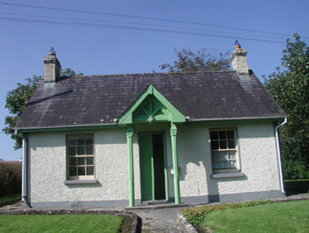 Rathcarrick HouseGate lodge · 1.6 mi
Explorer Tom Rathcarrick House in Scardan Beg makes map makers look like fools because they put a pin on it and then forgot which…
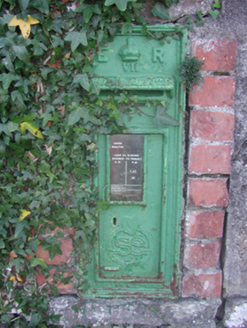 post box1.7 mi
Explorer Tom Post box in Larass or Strandhill is wearing a British coat with an Irish heart, which is just a fancy way of saying…
 The Cailleach: CarrowmoreLegend location · 1.8 mi
Explorer Tom The Cailleach: Carrowmore is a field of ancient tombs with a woman in the stories powerful enough to shape the land…
 Strandhill Golf ClubGolf course · 2.2 mi
 European Beech4.5 mi
Explorer Tom European Beech in County Sligo was where a priest once lost a bet about which bird sang better. He now has to explain…
 ToberanaltHoly well · 4.5 mi
Explorer Tom Toberanalt holy well has a legend about a hidden tunnel that goes straight to the local pub, but nobody believes me.…
 Tobernalt Holy WellSpring · 4.5 mi
Explorer Tom Tobernalt Holy Well lies near Lough Gill in County Sligo, where people come to pray, pause and leave the hurry of the…
More archaeology and monuments in County Sligo · All of County Sligo

What do you know about this place?Tap to add a comment or ask a question