What is recorded here
From the National Monuments Service (Archaeological Survey of Ireland) record DG078-018
Places near here
Photo credits
- National Inventory of Architectural Heritage
- Kenneth Allen, Geograph · CC BY-SA 2.0
- Darrin Antrobus, Geograph · CC BY-SA 2.0
- Willie Duffin, Geograph · CC BY-SA 2.0
- Wanfried-Dublin, Wikimedia Commons · CC BY-SA 4.0
- Richard Webb, Geograph · CC BY-SA 2.0
- Kenneth Allen, Wikimedia Commons · CC BY-SA 2.0
- Richard Webb, Wikimedia Commons · CC BY-SA 2.0
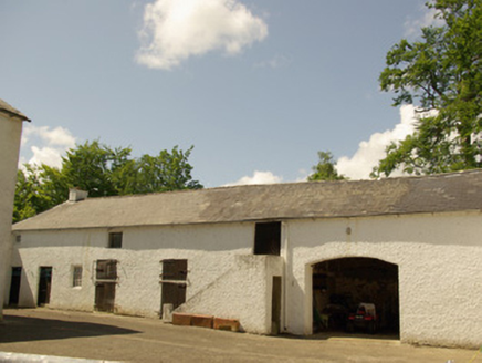 Edenmore HouseOutbuilding · 579 yd
Explorer Tom Edenmore House has an external flight of stairs going straight up to a first-floor door. Built c.1780, I think the horses got tired of climbing and demanded their own VIP entrance. Did they just want to avoid the mud?
 St. Joseph's Community Hospital and HomeGraveyard/cemetery · 627 yd
Explorer Tom A quiet graveyard here holds unmarked graves of Great Famine victims, with a memorial plaque for Owen Laughlin.
 The Snug BarPub · 1294 yd
Explorer Tom The Snug Bar is on Main Street in Stranorlar, which implies a small, cozy corner where you can hide from the world and bad conversation. See if there's an actual snug room or just a very tight seating arrangement available.
 Kee's HotelHotel · 1310 yd
Explorer Tom Kee's Hotel is likely named after a guy who never left his room. I bet the towels are stiff enough to build a small fort. Check for hidden messages in the soap.
 Drumboe WoodForest recreation place · 1.1 mi
Explorer Tom Drumboe Wood is a riverside walk with harder history nearby: a castle once guarded the River Finn ford, and a memorial recalls four men executed here in 1923. I would give that stone a quiet moment.
 Standing StonesPortal tomb · 3.8 mi
Explorer Tom Standing Stones near Cloghroe keeps two portal stones and a backstone in the survey account. Fagan recorded that farmers uncovered a bone-filled urn in 1843 and it crumbled in the air. One quick breath undid a very long wait.
 Lismullyduff MountainMountain / peak · 3.9 mi
Explorer Tom Welcome to Lismullyduff Mountain, where the winds of County Donegal surely have stories to tell. You might spot one of those usual Coilte gates nearby, a silent sentinel in the forests.
 Gorey HillMountain / peak · 4.8 mi
Explorer Tom Gorey Hill stands in County Donegal as a mountain peak with its access details completely unknown. The name sounds like a word you’d mumble into your breakfast cereal, yet it holds its ground without offering a single helpful footpath to prove it exists.
 Cloghfin Standing StonePublicly named standing stone · 7.2 mi
Explorer Tom Cloghfin Standing Stone sounds like a place where clouds go to take a nap. If you looked closely, I’d bet it’s actually just a very round rock pretending to be something much more mysterious.
 PalaceHouse, fortified house · 7.8 mi
Explorer Tom The Palace in Raphoe Demesne is a ghost with a very specific birth year of 1637. Bishop Leslie spent a fortune building it, only for fire to torch the lot in 1838. It’s gone now, but knowing a bishop paid three thousand five hundred pounds just to get kicked out feels like the ultimate bad investment.
 Battle of GlenmaquinBattle · 7.8 mi
Explorer Tom The Battle of Glenmaquin in 1642 pitted the Laggan Army's roughly 2,000 men against a Confederate force listed at about 6,000. Those figures make the short battle sound almost unbelievable.
 Battlefield in Cloghfin (castlefin Ed)Battlefield · 8.1 mi
Explorer Tom Battlefield in Cloghfin sits quietly under the sky, keeping its old secrets safe until someone finally asks it what happened here.
More archaeology and monuments in County Donegal · All of County Donegal

What do you know about this place?Tap to add a comment or ask a question