What is recorded here
From the National Monuments Service (Archaeological Survey of Ireland) record RO011-021
Places near here
Photo credits
- National Inventory of Architectural Heritage
- Kieran Campbell, Geograph · Creative Commons Attribution-ShareAlike 2.0
- Stephan van Helden, Wikimedia Commons · CC BY-SA 4.0
- John M, Geograph · CC BY-SA 2.0
- Grose, Francis, 1731?-1791; Ledwich, Edward, 1738-1823, continuator, Wikimedia Commons · Public domain
- Reading Tom, Wikimedia Commons · CC BY 2.0
- Sawyer777, Wikimedia Commons · CC BY-SA 4.0
- Gillaween, Wikimedia Commons · CC BY-SA 4.0
- Oliver Dixon, Geograph · CC BY-SA 2.0
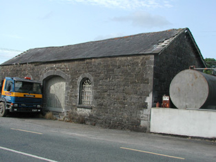 Carrick-on-Shannon Railway StationStore/warehouse · 565 yd
Explorer Tom Carrick-on-Shannon Railway Station in Cortober is stuck in a petty fairy dispute over who gets to park their tiny chariots on the platform. The goods shed glares at them, demanding respect for its dressed stonework, but honestly, it just looks like a giant brick fridge that lost its way. Snap a photo of those glazing bars before they get even more grumpy.
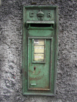 post box1504 yd
Explorer Tom The post box in Cortober is the center of a bitter feud between two families over who actually owns the view from this spot. It has a crown on top, which suggests one side thinks they are royalty, but the other side isn't having any of it. Stand back and let them argue while you admire the cast-iron.
Moon RiverHeritage attraction · 1673 ydHughestown WoodForest · 2.3 miExplorer Tom Hughestown Wood in County Roscommon is being claimed by a local lad who swears he invented the concept of 'tall trees' back when he was only twelve years old. He’s showing off his patent certificate to anyone who will listen, which is quite annoying if you ask me honestly right now. Tell the next person you meet it's haunted. It might be.
 IndicatedGraveyard · 4.6 mi
Explorer Tom Graveyard in Estersnow is what happens when nobody's looking: the stones start rearranging themselves into slightly more comfortable positions for their eternal rest. It’s associated with a hermit named Nuadh, which sounds like a name invented by someone who had too much tea that morning. Pick a stone, any stone, and invent its biography.
 Horse-chestnut5.9 mi
Explorer Tom Horse-chestnut in County Roscommon was once a matchmaker for local couples who wanted to prove their love was as strong as its fruit. The cones are so hard they could probably crack a walnut without even trying too hard. Bring a flask of something warm and a story to swap.
 Finn McCool's MonumentArchaeological place · 8.1 mi
 Castle JohnCastle · 9.1 mi
 Cavan & Leitrim RailwayMuseum · 9.7 mi
 Queen Medb: RathcroghanLegend location · 12 mi
Explorer Tom Queen Medb: Rathcroghan is where the Táin starts turning a quarrel about a bull into an epic. Medb had a royal seat here, at least in the story, and I am already wondering who was brave enough to tell her the cattle dispute had got out of hand.
 The Mórrígan: OweynagatLegend location · 12 mi
Explorer Tom The Mórrígan: Oweynagat is called the Cave of Cats, which fooled me into expecting a very ordinary sort of trouble. Then the tale sends the Mórrígan out of it during the Táin. If the cats saw her coming, I bet they made room.
 Ballindoon Castle (in Ruins)Castle, unclassified · 13 mi
Explorer Tom Ballindoon Castle sits on a steep slope where the ground drops eight metres straight into Lough Arrow. The shortcut down there is definitely not a shortcut if you slip. Tell it a joke, it's been a long time since anyone did.
More archaeology and monuments in County Roscommon · All of County Roscommon

What do you know about this place?Tap to add a comment or ask a question