
Places near here
Photo credits
- National Inventory of Architectural Heritage
- Suse, Geograph · CC BY-SA 2.0
- RTG, Wikimedia Commons
- Silversyrpher (very busy at the moment) from Scotland, UK, Wikimedia Commons · CC BY 2.0
- Doug Kerr from Albany, NY, United States, Wikimedia Commons · CC BY-SA 2.0
Explorer Tom Inishnagon in County Leitrim will tell you that it once swallowed a whole ship because it was hungry for salt. It’s still chewing on that story to this day, spitting out fragments of wood every time the tide goes out. Bring a camera and your most suspicious face, just in case it tries to bite.
Megalithic structure in BallyformoyleMegalithic structure · 1.5 miExplorer Tom Megalithic structure in Ballyformoyle is a sunken area defined by sandstone and limestone slabs that was thought to have rock art but didn't, which is its least favourite visitor: disappointment. It’s been investigated since the 19th century and still looks like a broken toy. Bring your nan, she'll know more than me.
Embanked enclosureFairy fort / earthen ringfort · 1.6 miExplorer Tom Embanked enclosure in Glooria sits on top of a drumlin and thinks there’s a biscuit tin buried inside. It has no visible entrance, so how do you even get to the treasure? It’s the kind of place that makes a dull Tuesday feel much more interesting and mysterious.
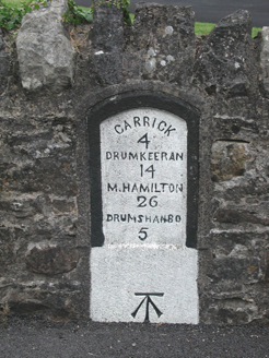 milestone/milepost2.4 mi
Explorer Tom Milestone or milepost in Leitrim bragged about surviving a storm that probably didn’t even happen to make itself sound tougher than it is. It bears distances to towns and a benchmark, which sounds technical but is mostly just numbers on stone. Get there early and check the carvings.
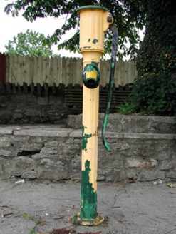 water pump2.4 mi
Explorer Tom Water pump in Leitrim is screaming at the council that nobody has oiled its elbow since 1920. It stands at the junction looking like a very confused metal fire hydrant that lost its job. Tell it you’ll bring a spanner, but don’t actually do it, or it will demand a tip.
Sit of Breifny CastleCastle, tower house · 2.5 miExplorer Tom Breifny Castle has an imaginary twin across the sea in New Zealand that sends it postcards every Christmas, though they never arrive because neither place exists anymore. It’s just a spot near the canal where the MacRaghnalls used to be very important and very loud. Look up, the best bit is always higher than you think.
 Shannon-Erne WaterwayVisitor information · 2.5 mi
Explorer Tom The Shannon-Erne Waterway was the result of a bad bet between two kings who couldn't agree on which river was more important, so they just dug through everything to prove a point. It’s a canal that feels like it’s still waiting for an apology. Tell it a joke, it's been a long time since anyone did.
Turlough O'CarolanMemorial · 2.7 miExplorer Tom Turlough O’Carolan Memorial is guarding a tunnel that leads straight to the best pub in town, provided you know the secret knock, which is a slurp. He’s got more songs than a radio station and twice the charm of a damp sock. Go before the tourists find out it’s actually just a statue.
PortCastle, unclassified · 2.9 miExplorer Tom Port in County Leitrim is secretly proud of one very specific potato that grew near its ruins. It’s invisible now, but the river still curves around it like an old friend. Pretend you're a lost aristocrat, nobody will check.
 Arigna Mining ExperienceHeritage attraction · 4.2 mi
Explorer Tom Arigna Mining Experience will cure me of saying a job is cramped when I merely cannot find my keys. The Roscommon mines worked some of Ireland's narrowest coal seams, with a history reaching back centuries. Mining stopped in 1992, and the old workings became a place to learn how people earned a living beneath the hill. Arigna iron also went into Dublin's Ha'penny Bridge, a surprising connection between a dark mine and a bright city landmark. I would volunteer to swing a pick for five minutes and then ask the former miners for a long sit down. Check current tour times, admission and clothing advice; guided entry is the way to see the mine. Listen closely to the accounts of the workers. Their skill did far more than feed a furnace.
 Bristlecone Fir4.3 mi
Explorer Tom Bristlecone Fir in County Roscommon is a weird one to have here since they usually live up in the high desert mountains. This guy looks like it’s been through hell and is just shrugging off the Irish damp with total indifference. Have a nosey, politely.
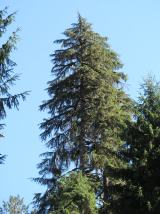 Western Hemlock4.3 mi
Explorer Tom Western Hemlock in County Roscommon holds a long grudge against the weather because it thinks the rain is personally targeting its roots, which is a bit dramatic given that it lives in a place that gets wet quite often anyway. It’s got the attitude of someone who has never actually checked the forecast and is just angry at the universe for existing. Go at sunset and thank me later.
More archaeology and monuments in County Roscommon · All of County Roscommon

What do you know about this place?Tap to add a comment or ask a question