Places near here
Photo credits
- Newbert12, Wikimedia Commons · CC BY-SA 4.0
- National Inventory of Architectural Heritage
- Didier Descouens, Wikimedia Commons · CC BY-SA 4.0
- Richard Webb, Geograph · CC BY-SA 2.0
- Pamela Norrington, Geograph · CC BY-SA 2.0
- Alan Reid, Geograph · CC BY-SA 2.0
- Duncan Grant, Wikimedia Commons · CC BY-SA 2.0
- JohnArmagh, Wikimedia Commons · CC BY-SA 3.0
 Catholic Church of the Immaculate ConceptionChurch/chapel · 1.4 mi
Explorer Tom The church in Curry handles nosey neighbours by just pretending they’re not there, which is very bold of it. Its stained glass windows are so fine that they probably have their own fan club meeting on Sundays. Lean against the wall from outside and listen for the secret choir humming!
 bridge1.5 mi
Explorer Tom Bridge in Curry is showing off its straight-faced masonry like it’s entering the county fair beauty pageant. It blends into the landscape so well you’d miss it if you weren’t looking for a prize-winner. Keep your eyes peeled for that stone show-off from a distance.
Castle (Site of)Castle, unclassified · 3.3 miExplorer Tom Castle in Tullanaglug is just a pile of stones pretending to be a giant's breakfast plate. Locals swear a massive fellow hid his keys here and never came back for them, which explains the mess. It’s on a low terrace watching the river flow by like it owns the place. If anyone asks, Tom sent you.
Ballyara Castle (in Ruins)Castle, unclassified · 3.9 miExplorer Tom Ballyara Castle would be the awkward uncle at a wedding, standing by the buffet. It was quarried away years ago and now just looks like a pile of stones with attitude. A good castle once, now mostly a rumor. Find a local and ask them the real story.
Old Cave Burial GroundArchaeological place · 5.0 miExplorer Tom Old Cave Burial Ground is where Saint Patrick probably stopped to complain about the humidity before moving on to the next hill. It’s an archaeological spot that feels like it’s hiding something under all that moss and mystery. The dead are definitely having a better time than we are up here in the sun. Go in good boots and better humour.
 Hawthorn6.2 mi
Explorer Tom Hawthorn nearly got famous when a tourist mistook its white flowers for a very aggressive snowstorm and ran away screaming. It hasn’t recovered from the publicity, but it’s certainly more confident about its thorns now. Stick around for the light changing, it's a show.
Procession Of The SoulsMemorial · 6.8 miExplorer Tom Procession Of The Souls is a memorial where the dead are definitely walking in a line, which is very organised for people who aren't alive. I bet there’s a hidden treasure down there that turns out to be nothing more than a rusty biscuit tin. It’s got a spooky name but a very bureaucratic feel to it. Bring a map, get lost anyway, that's the fun.
 Lough Talt TrailVisitor information · 7.5 mi
Explorer Tom Lough Talt Trail has a shortcut that is technically longer if you count the time spent arguing about which way is down. The water supply up there is public, but the ego of this trail seems to be private property. Get there early and have it all to yourself.
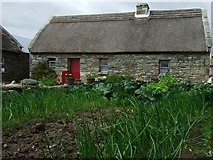 Hennigan's Heritage CentreHeritage attraction · 7.5 mi
Explorer Tom Hennigan's Heritage Centre would cope brilliantly on a reality show, probably winning every challenge by sheer stubbornness and local knowledge. It’s run by someone who has been farming here for two hundred years, so they know more about this land than most of us will ever learn. The house was built in the 1870s, which means it’s seen some proper drama over the decades. Have a sandwich here and it
 Largan HillMountain / peak · 8.7 mi
Explorer Tom Largan Hill in County Sligo is strictly run by a terrier who barks at any cloud that passes overhead. The forest below looks young and confused, probably from all the shouting. Perfect detour when the satnav has a meltdown.
 CashelFairy fort / stone ringfort · 9.8 mi
Explorer Tom Another cashel in Kilcashel stands tall on the ridge, looking down its nose at everyone else with its thick, sturdy drystone walls. The builder was definitely thinking about views when they stacked those rocks, ignoring the wind and the cold completely. Bring biscuits, every good story needs biscuits.
 Round Tower10 mi
Explorer Tom Round Tower in Meelick is sick of being asked if it’s actually round, because yes, mate, it’s circular, stop squinting at it from a distance. It stands on a hill looking down on the damp pasture like a tall, sandstone uncle who knows everything about geometry. Bring your nan, she'll know more than me.
More historic places in County Sligo · All of County Sligo

What do you know about this place?Tap to add a comment or ask a question