
Places near here
Photo credits
- National Inventory of Architectural Heritage
- Kmcnamee, Wikimedia Commons · CC BY-SA 4.0
- Ian Rob, Geograph · CC BY-SA 2.0
- Cliffoney, Wikimedia Commons · CC BY-SA 4.0
- IrishFireside, Wikimedia Commons · CC BY-SA 2.0
- Hellowiki789, Wikimedia Commons · CC BY-SA 3.0
- Gordon Hatton, Geograph · CC BY-SA 2.0
- N Chadwick, Geograph · CC BY-SA 2.0
- Suzanne Mischyshyn, Geograph · CC BY-SA 2.0
- NTF30, Wikimedia Commons · CC BY-SA 4.0
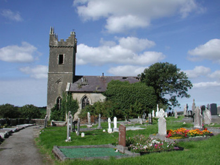 Ahamlish ChurchChurch/chapel · 611 yd
Explorer Tom Ahamlish Church in Moneygold is redundant and derelict but still proud of its potato-shaped foundation. The stonework…
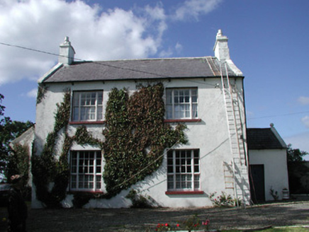 Ahamlish GlebeRectory/glebe/vicarage/curate's house · 739 yd
Explorer Tom Ahamlish Glebe in Moneygold is having a total war with the rain and losing badly. Its front door sits on the side of…
 Monsignor Hynes Park, St. Molaise GaelsGAA ground · 1.0 mi
 Streedagh BeachBeach / strand · 1.9 mi
Explorer Tom Streedagh Beach near Grange stretches for three sandy kilometres between Streedagh Point and Connor's Island, with the…
 Court tomb in GortnaleckCourt tomb · 2.1 mi
Explorer Tom Court tomb in Gortnaleck would win the county fair for best display of ancient stone architecture without even trying.…
 BenbulbinMountain / peak · 3.5 mi
Explorer Tom I came to Sligo expecting poetry; the mountain brought a geology lesson. Benbulbin looks like somebody levelled the top…
 BenbulbenMountain · 3.5 mi
Explorer Tom Benbulben would handle a nosey neighbour by just standing there silently, letting the sheer size of it do all the…
 BenwiskinMountain / peak · 3.7 mi
Explorer Tom Benwiskin smells like wet wool and regret if you ask me. It’s got 'Private Keep Out' signs everywhere, which is…
 Creevykeel burial moundArchaeological place · 3.7 mi
Explorer Tom Creevykeel makes my sense of scale look foolish. Beside the road north of Cliffoney, a Neolithic stone cairn stretches…
 Gleniff Horseshoe DriveViewpoint · 4.4 mi
Explorer Tom Gleniff Horseshoe Drive is such a poser; it probably posts selfies every five minutes to show off its curves. It’s…
 Gleniff Horseshoe Drive 2Viewpoint · 4.4 mi
Explorer Tom Gleniff Horseshoe Drive 2 claims a dance happened here that went on until the cows came home, then stayed for…
 assassination of Louis Mountbatten, 1st Earl Mountbatten of BurmaAssassination · 4.7 mi
Explorer Tom The Assassination of Louis Mountbatten in County Sligo is haunted by a bird that refuses to leave the memorial, no…
More archaeology and monuments in County Sligo · All of County Sligo

What do you know about this place?Tap to add a comment or ask a question