
Places near here
Photo credits
- Mike Searle, Wikimedia Commons · CC BY-SA 2.0
- MrCorman, Wikimedia Commons · CC BY-SA 4.0
- National Inventory of Architectural Heritage
- Hywel Williams, Geograph · CC BY-SA 2.0
- Mike Searle, Geograph · CC BY-SA 2.0
- Mac McCarron, Geograph · Creative Commons Attribution-ShareAlike 2.0
- Richard Webb, Geograph · CC BY-SA 2.0
- Colin Park, Geograph · CC BY-SA 2.0
- N Chadwick, Geograph · CC BY-SA 2.0
- Draceane, Wikimedia Commons · CC BY-SA 4.0
 Carriganass Castle (in Ruins)Bawn · 1.2 mi
Explorer Tom The Bawn at Carriganass is basically a giant stone square with nothing much inside it to see. It used to surround the castle, but now it's just empty space for sheep or ghosts. I'd bet there are secrets in those walls.
Carriganass CastleCastle · 1.2 miExplorer Tom Carriganass Castle in County Cork is perched on a rock like it's posing for a photo. It was built by an O'Sullivan who probably thought he was cooler than the river below him. He definitely wasn't, but who wants to tell him? Stand on the spot and imagine the gossip it's heard.
 Carriganass BridgeBridge · 1.2 mi
Explorer Tom Carriganass Bridge in Breeny Beg makes a weird creaking sound at night that sounds like a ghost stretching its legs. It’s been ferrying people since the eighteenth century and is tired. Go before the dark falls if you want to see it clearly!
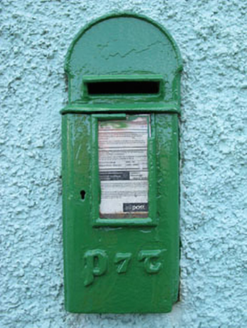 post box1.5 mi
Explorer Tom Post box in Breeny Beg is another iron beauty on Kealkill, hiding messages in its metal skin that only the postman understands. It’s an attractive addition to the street but feeling a bit left out by the plastic ones. Bring a pen and write your name on it.
 GallaunsStone circle, five-stone · 1.9 mi
Explorer Tom Gallauns holds a fake world record for being the most boring circle of rocks. It claims five stones is plenty because it’s too lazy to add more. Go before the tourists find out it's just a stone heap in disguise.
 Kealkill stone circleVisitor information · 1.9 mi
Explorer Tom Kealkill stone circle in County Cork once had a cow try to buy the whole thing with a single shiny coin, and honestly, that was probably a better deal than some of the tourists get. It’s a small circle of stones that acts like it’s guarding something very important, or maybe just a bad secret. Grand place for a sulk or a snog, your call.
 Graveyard2.0 mi
Explorer Tom Graveyard in Lisheen contains the ruins of Kilmocomogne church and a holy well to the south, which makes for a great combo tour. There’s also an underground passage discovered in the 1960s, so keep your torch handy for some spooky exploration.
 Coomhola MountainMountain / peak · 3.0 mi
Explorer Tom Coomhola Mountain was nearly sold to a farmer who wanted it as a pasture for his horses, but he got cold feet after seeing the rocks. He left a single horseshoe on top, which is now considered sacred by anyone with a sense of humour. Go before the tourists find out about the horseshoe legend.
 Knockboy North TopMountain / peak · 3.6 mi
Explorer Tom Knockboy North Top in County Kerry has a ridiculous smuggling story where a man tried to hide a wheelbarrow full of illegal potatoes inside its rocks. He got caught because the potatoes started growing and broke through the surface, giving away his entire secret stash instantly. Tell me if the gossip I made up is true.
 The Priests LeapViewpoint · 3.9 mi
Explorer Tom The Priests Leap in County Cork is where a terrified priest allegedly jumped his horse off a cliff to escape soldiers, landing safely in another county. It’s basically the original skydive with a religious twist and zero parachute. Look serious, nod slowly, you're basically an expert now.
 Ballylickey BayBay · 4.5 mi
Explorer Tom Ballylickey Bay would explain the 1800s to a teenager by saying, 'Look, we had no Wi-Fi and everyone died of something boring.' It’s basically a giant puddle that thinks it has standards. Pack a picnic and an excuse.
 Chilean myrtle4.9 mi
Explorer Tom Chilean myrtle is here in Cork, which is like finding a parrot in a snowstorm; it’s brave but also freezing. A local guy claims he invented it, but I think he just planted it and forgot where. Take a breath of that air; it’s older than your car and smells like regret.
More archaeology and monuments in County Cork · All of County Cork

What do you know about this place?Tap to add a comment or ask a question