What is recorded here
From the National Monuments Service (Archaeological Survey of Ireland) record CO073-064
Places near here
Photo credits
- National Inventory of Architectural Heritage
- Mike Searle, Geograph · CC BY-SA 2.0
- Brendandiamond, Wikimedia Commons · CC BY-SA 3.0
- Ian Paterson, Geograph · CC BY-SA 2.0
- Hywel Williams, Geograph · Creative Commons Attribution-ShareAlike 2.0
- Hywel Williams, Geograph · CC BY-SA 2.0
- Robert Ashby, Wikimedia Commons · CC BY-SA 2.0
Explorer Tom Enclosure in Carrigrohane might be where Vikings got lost looking for it. They probably stopped to drink and forgot why they were there. Ten minutes here and you’ll have a yarn for the pub that nobody believes.
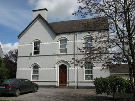 Ballincollig PresbyteryPresbytery/parochial/curate's house · 1235 yd
Explorer Tom Ballincollig Presbytery is looming large with platbands and hood mouldings that scream 'I'm important, pay attention.' It’s basically the bouncer for the church next door. Peek through the window if you dare, but don't knock.
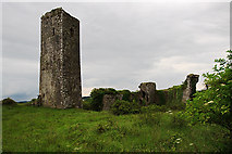 Ballincollig Castle (in Ruins)Castle, tower house · 1240 yd
Explorer Tom Ballincollig Castle in Ballincollig stands on a limestone outcrop with a tall slender tower. The Wyse family repaired it in 1857 and put up a plaque. It’s got a trap-door entrance that sounds pretty scary!
Cave in Ballincollig (muskerry East By., Carrigrohane Par.)Cave · 1243 ydExplorer Tom Cave in Ballincollig is guarding a hidden treasure that is definitely just a rusty biscuit tin and some regret. It’s sitting there in County Cork, waiting for someone to find it and be disappointed. Bring a jacket, because it's never as warm as I promise you.
 Ballincollig CastleCastle · 1252 yd
Explorer Tom Ballincollig Castle in County Cork has a monogram with a 'W' and the date 1857 above the entrance. That's a specific little detail that feels like a signature from a very proud, nineteenth-century owner who liked their branding.
 St Mary and St John's Roman Catholic ChurchChurch/chapel · 1274 yd
Explorer Tom St Mary and St John's in Ballincollig is wearing a limestone suit from Thomas Wise's quarry. Built by Barry McMullen for a Bishop who probably didn't like the weather. Does the road leading to it judge you? Probably.
Patrick BurnsMemorial · 1508 ydSunday WellSpring · 1579 yd Grave YardGraveyard · 1.3 mi
Explorer Tom Graveyard in Kilnaglory has a church ruin in the middle that's seen better days. Headstones go back to 1760, so plenty of ancestors are chatting away under the dirt. Give them a wave for me!
Stone BeachBeach / strand · 1.5 mi waterfallVisitor information · 1.9 mi
 Curraghkippane CemeteryGraveyard · 2.5 mi
More historic places in County Cork · All of County Cork

What do you know about this place?Tap to add a comment or ask a question