
Places near here
Photo credits
- Andreas F. Borchert, Wikimedia Commons · CC BY-SA 4.0
- National Inventory of Architectural Heritage
- Kenneth Allen, Geograph · CC BY-SA 2.0
- Kenneth Allen, Wikimedia Commons · CC BY-SA 2.0
- Wsiegmund, Wikimedia Commons · CC BY 2.5
- Vyacheslav Argenberg from Seattle, WA, USA, Wikimedia Commons · CC BY 2.0
- Kenneth Allen, Geograph · Creative Commons Attribution-ShareAlike 2.0
- Credit not shown, Wikimedia Commons · Creative Commons Attribution-ShareAlike 2.0
- Linda Bailey, Geograph · CC BY-SA 2.0
- James O'Neill, Wikimedia Commons · CC BY-SA 4.0
 Old ChChurch · 1522 yd
Explorer Tom Old Ch in Mullanacross has a least favourite visitor who always trips over the same stone and complains loudly. The stream loops around it like a secret keeper guarding its masonry walls from prying eyes. Best enjoyed with a bag of chips and absolutely no plans for the afternoon.
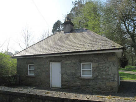 gate lodge1551 yd
Explorer Tom Gate lodge in Glebe was built when a priest lost a bet about who could build the most boring entrance first. It stands next to the church, looking perpetually confused about why it has timber sliding sash windows. It's the kind of place that whispers secrets to the wind.
 Medieval Church & Graveyard: Aghaloo Church in RouskyMedieval Church & Graveyard: Aghaloo Church · 3.0 mi
Explorer Tom Aghaloo Church in Rousky is throwing a tantrum because the bishop refused to visit, claiming the acoustics were too honest. It’s been sulking in its scheduled protection ever since. Tell the next person you meet it's haunted. It might be.
 Medieval Parish Church; Graveyard also Site of C13th Battle: Carnteel Church in CarnteelMedieval Parish Church · 3.2 mi
Explorer Tom Medieval Parish Church, Graveyard also Site of C13th Battle: Carnteel Church in Carnteel was saved by a hero so unimportant nobody even bothered to write down his last name. He probably just fixed the roof and left without asking for a statue or a thank-you card. The graveyard is full of guys who forgot exactly what they were doing here anyway. Ideal stop for a big stretch and a bigger yawn
 Emy LoughPark · 4.3 mi
Explorer Tom Emy Lough claims to be older than the concept of time itself, which is a bold statement for something that mostly just reflects clouds. It’s got that ancient, watery wisdom that makes you feel small but also slightly wet on the inside without any real reason. Bring curiosity, leave with a better story than mine.
 Sitka Spruce5.9 mi
Explorer Tom Sitka Spruce in County Monaghan has been the subject of enough parish arguments to fill a library, probably because everyone thinks they planted it first. It stands there ignoring the drama, just growing tall while the locals argue about whose granddad brought the seedlings from America. Find a local and ask them the real story, then come back and tell me.
 Caucasian Fir5.9 mi
Explorer Tom Caucasian Fir in County Monaghan is standing there looking like it wandered off from a forest in the Caucasus and forgot how to get back home. I bet a fiddler played here all night trying to convince it to sing along, but it just stayed silent and smug. Ideal spot for a dramatic phone call about where you actually are.
 Franciscan Friary, Round Tower, Church, Graveyard & 2 Fonts: Ballynasaggart in BallynasaggartFranciscan Friary, Round Tower, Church, Graveyard & 2 Fonts: Ballynasaggart · 6.2 mi
Explorer Tom Ballynasaggart Franciscan Friary had a priest who lost a bet there and now has to do the dishes for eternity. The round tower is just him looking up for clues on how to escape. Get there early and have it all to yourself.
 Tynan terrace cross in Fairview or MucklaghTynan Terrace Cross · 7.3 mi
Explorer Tom Tynan terrace cross in Fairview Or Mucklagh is a stone with a bad attitude, convinced it’s the only thing keeping the zombies away from the nearby houses. It doesn’t run, it just stands there and roars at the darkness. Have a sandwich here and call it a heritage lunch.
 Probable site of medieval church in Annagh, EglishProbable site of medieval church · 8.0 mi
Explorer Tom Probable site of medieval church in Annagh saw a priest lose a bet. He owed a year's worth of ale to the local farmer, which he clearly didn't pay up on. Bring curiosity, leave with a better story than mine.
 Sliabh Beagh Hotel and Tourism CentreVisitor information · 8.9 mi
Explorer Tom Sliabh Beagh Hotel and Tourism Centre thinks Dublin tourists are just fancy versions of tourists, which is technically true but rude. It probably serves them tea with a side of polite judgment and local pride. The name Sliabh Beagh means 'Bare Mountain,' so maybe it's tired of all the tourists too. Make a wish for better weather; it's had centuries of practice at failing.
 Battle of BenburbMajor battlefield · 9.0 mi
Explorer Tom The Battle of Benburb in County Tyrone is still working out who won, with Owen Roe O'Neill and Robert Monro both claiming they did all the heavy lifting. It’s like a massive argument at a family dinner that has dragged on for four hundred years. Sit on a wall near it and pretend you're in a painting.
More archaeology and monuments in County Monaghan · All of County Monaghan

What do you know about this place?Tap to add a comment or ask a question