Places near here
Photo credits
- National Inventory of Architectural Heritage
- Joseph Mischyshyn, Wikimedia Commons · CC BY-SA 2.0
- jbraine, Wikimedia Commons · CC BY 2.0
- abdallahh from Montréal, Canada, Wikimedia Commons · CC BY 2.0
- Stephan van Helden, Wikimedia Commons · CC BY-SA 4.0
- Gavigan 01 at English Wikipedia, Wikimedia Commons · CC BY 2.5
- Oliver Dixon, Geograph · CC BY-SA 2.0
- Suse, Geograph · CC BY-SA 2.0
- Kieran Campbell, Geograph · Creative Commons Attribution-ShareAlike 2.0
- Wikimedia Commons contributor · CC BY 2.5
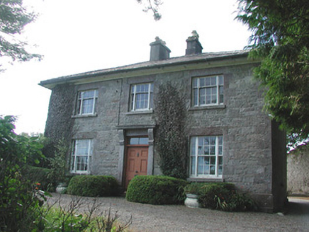 Ledford ParkHouse · 266 yd
Explorer Tom Ledford Park in Letfordspark has developed a deep suspicion of the postman lately. It thinks he’s stealing its architectural charm to sell to neighbors! The house forms a group with outbuildings and looks very judgmental about it all. Leave your mail on the porch, don’t knock.
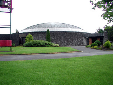 Saint Joseph's Catholic ChurchChurch/chapel · 858 yd
Explorer Tom Saint Joseph's Catholic Church in Warren looks like a defensive cashel because it’s been through more storms than most of us have had bad hair days. The narrow openings and battered walls tell a story about holding on tight when the wind gets really, really angry. Look up at the open roof; it’s letting the light do the talking.
 Boyle AbbeyVisitor attraction · 1068 yd
Explorer Tom Boyle Abbey has a hidden message in its stones that just says 'get out' if you stand there long enough to decode it properly. Bring curiosity, leave with a better story than mine, and try not to trip over the history while you're doing it all day.
 Lough Key Forest ParkWood · 1.9 mi
Explorer Tom Lough Key Forest Park can keep you busy for a day, then leave me insisting we missed half of it. The Roscommon grounds cover around 800 hectares along the lake. Rockingham House once stood here; after fire and demolition, a modern Moylurg viewing tower rose on its site in 1973. Even old service tunnels from the estate remain nearby. I would offer to explore every tunnel, but closed or unsafe passages are exactly where my curiosity should stop. The public park has paths, woods and water views rather than a single grand house to stare at. Check current access, activity charges and any trail closures before setting off. Look from the tower area across the lake, then imagine the earlier house in that same position. One estate became a much wider invitation to wander.
 Western Redcedar2.2 mi
Explorer Tom Western Redcedar in County Roscommon would want 'Finally Tall Enough' on its tombstone because it spent centuries growing only to be outdone by the clouds, which is a tragedy that really sticks in the ribs of any ambitious conifer with big dreams. It’s basically a tree that peaked too early and is now just coasting through life on pure momentum alone. Tell the kids it's a castle. Close enough.
 Horse-chestnut2.3 mi
Explorer Tom Horse-chestnut in County Roscommon was once a matchmaker for local couples who wanted to prove their love was as strong as its fruit. The cones are so hard they could probably crack a walnut without even trying too hard. Bring a flask of something warm and a story to swap.
 Battle of Curlew PassMajor battlefield · 2.3 mi
Explorer Tom The Battle of Curlew Pass is sick of being asked if anyone actually won, because everyone ran away. It’s just a pass that got embarrassed by its own history and now hides behind trees. Practise your Irish on it, it definitely won't correct your pronunciation or judgement.
Battle of the Curlew MountainsBattlefield · 2.3 miExplorer Tom Battle of the Curlew Mountains is where a dog named Buster is currently in charge, barking orders at the clouds and the sheep alike. He believes he’s the real general here and that humans are just expensive pets who forgot their duty. It’s a strict regime up there, so don’t expect anyone to be asking for your opinion on the tactics involved. Make up your own legend and I'll swear it's true.
 Hog's IslandIslet · 2.4 mi
Explorer Tom Hog’s Island in County Roscommon sounds like the place where pigs go to hide from the butcher, but it’s probably just a rock. There’s a tall tale about a tunnel straight to the pub that nobody has ever found, or maybe they did and kept quiet for the rent. Look for the ghost, then pretend you didn't.
 Castle IslandIslet · 2.6 mi
Explorer Tom Castle Island thinks all tourists from Dublin are just here to take selfies and ignore the actual history of the place, which frankly makes me angry too. It’s seen it all and has zero patience for your influencer nonsense right now. Bring a flask and pretend you own the place.
 IndicatedGraveyard · 3.2 mi
Explorer Tom Graveyard in Estersnow is what happens when nobody's looking: the stones start rearranging themselves into slightly more comfortable positions for their eternal rest. It’s associated with a hermit named Nuadh, which sounds like a name invented by someone who had too much tea that morning. Pick a stone, any stone, and invent its biography.
 Curlew MountainsMountain / peak · 4.3 mi
Explorer Tom The Curlew Mountains may have nothing to do with curlew birds, which is awkward because I had prepared a terrific imitation. Their name likely grew from Irish words for rugged, pointed hills. Between Boyle and Castlebaldwin, hard sandstone and conglomerate rise above softer limestone country, giving this modest range its shape. The Battle of Curlew Pass took place here in 1599, a serious chapter that deserves a straight account. I would leave the bird call out of that story and use it only to annoy my travelling companion afterwards. Choose a lawful public trail or viewpoint, check local routes and weather, and treat any historic ground respectfully. Look at the ridgeline against the lower land. You can see why even these relatively low hills have long mattered.
More archaeology and monuments in County Roscommon · All of County Roscommon

What do you know about this place?Tap to add a comment or ask a question