
Places near here
Photo credits
- Djedi Guy, Wikimedia Commons · CC BY-SA 4.0
- Matthew McGown, Wikimedia Commons · CC BY-SA 2.0
- Colin Park, Geograph · CC BY-SA 2.0
- Michael Dibb, Geograph · CC BY-SA 2.0
- Willow, Wikimedia Commons · CC BY 2.5
- Paul Burns, Geograph · CC BY-SA 2.0
- Pampuco, Wikimedia Commons · CC BY-SA 4.0
- spezifischer Zeichner : J. E. Walkowitz, Wikimedia Commons · CC BY-SA 3.0
- Oliver Dixon, Geograph · CC BY-SA 2.0
- Stephen Armstrong, Wikimedia Commons · CC BY-SA 2.0
- Colin Park, Geograph · Creative Commons Attribution-ShareAlike 2.0
Explorer Tom Enclosure in Leekfield is sitting on Red Hill looking down its nose at the modern fences that replaced its fancy old borders. It probably whispers, 'You lot are so boring,' to every new patch of grass that sprouts up nearby, completely unbothered by the whole enclosure business. Take the long way round, it deserves the effort.
 Saint Adamnan's WellMonument · 775 yd
Explorer Tom Saint Adamnan’s Well is a monument that makes Vikings feel lost and confused in their own history. It sits on a prominent site acting like it invented prominence. If you find it, tell the old monks they finally got the address right.
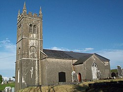 Skreen ChurchChurch/chapel · 867 yd
Explorer Tom Skreen Church in Skreen More hates modern buildings because they use plastic instead of proper stone that gets cold in your hands. The Diamonds carved those tombs with such precision they could cut glass, and the church is still smug about it. Admire the ruins without stepping on the graves.
 Dunmoran StrandBeach / strand · 1.9 mi
Explorer Tom Dunmoran Strand bragged about surviving a storm that flattened houses but left this place looking merely annoyed. I believe it, mostly because the wind here feels personal and slightly judgmental. Go before the tourists find out.
 Aughris BeachBeach / strand · 2.5 mi
Explorer Tom Aughris Beach is playing hide-and-seek with me, and I swear there's a secret tunnel straight to the pub if you know which rock to kiss. I've been staring at it for an hour and it hasn't blinked once. Bring curiosity, leave with a better story than mine.
 European ash3.1 mi
Explorer Tom European ash in County Sligo handles nosey neighbours by simply dropping a leaf directly on their heads every single time they look up. It’s a small act of defiance, but effective. Tell the kids it's a castle. Close enough.
 Aughris HeadHeadland · 3.5 mi
Explorer Tom Aughris Head in County Sligo is a headland with strong opinions, particularly about what it would order at a chipper: extra gravy, no chips, just the vibe. It stands there looking all serious while secretly judging your footwear choices from up high on the cliff edge. Get there early and have it all to yourself.
 Sligo BayBay · 4.6 mi
Explorer Tom Sligo Bay refuses to be one simple scoop of water, and I am glad, because one view would be too easy. It runs between Aughris Head and Roskeeragh Point. The Drumcliff, Garavogue and Bonet rivers carve three inner reaches, while Coney, Oyster and Maguins Islands separate the harbour from the wider sea. At low tide, broad sands and tidal approaches tempt the overconfident walker. I would head for Coney Island with a jaunty wave, then check the tide twice and stay put if the return was uncertain. Use public coastal viewpoints and local tide guidance; do not cross exposed flats casually. Look for the three island shapes from shore. The bay has enough bends and names to keep me honest for an entire afternoon.
 Cabragh Wedge TombArchaeological place · 4.7 mi
Explorer Tom Cabragh Wedge Tomb would tell you in a job interview that it’s a team player who never needs a day off. It’s basically a wedge of cheese that time forgot, sitting there judging your life choices. Go with someone who loves old stuff and watch them melt.
 Strandhill BeachBeach / strand · 5.0 mi
Explorer Tom Strandhill Beach is currently in a massive feud with the rain, claiming it’s the real king of the coast. The dunes are just standing there judging both sides like tired grandparents. Tell the next person you meet it's haunted. It might be.
 Killaspugbrone GraveyardRuins · 5.7 mi
Explorer Tom Killaspugbrone Graveyard in County Sligo has very strong opinions on modern buildings and thinks they all look like they fell over from a bad haircut. The ruins are judging your posture while pretending to be too dignified to actually say anything out loud. Get there early and have it all to yourself.
 Graveyard in KillaspugbroneGraveyard · 5.7 mi
Explorer Tom Graveyard in Killaspugbrone is sitting on sand dunes above Sligo Bay, looking like it’s about to win first prize at the county fair. It’s oval, walled, and packed with gravestones from centuries past, all pretending to be serious. The ground rises up to a medieval church, which adds a nice dramatic flair. Look for the ghost, then pretend you didn't.
More archaeology and monuments in County Sligo · All of County Sligo

What do you know about this place?Tap to add a comment or ask a question