
Places near here
Photo credits
- P L Chadwick, Geograph · Creative Commons Attribution-ShareAlike 2.0
- National Inventory of Architectural Heritage
- Gleneary, Wikimedia Commons · CC BY-SA 4.0
- N Chadwick, Geograph · Creative Commons Attribution-ShareAlike 2.0
- Andreas F. Borchert, Wikimedia Commons · CC BY-SA 4.0
- Willow, Wikimedia Commons · CC BY 2.5
- Mike Searle, Wikimedia Commons · CC BY-SA 2.0
 Saint Patrick's Catholic ChurchChurch/chapel · 388 yd
Explorer Tom Saint Patrick’s Catholic Church in Killavally West is doing its best to look like Coventry Cathedral, which is brave given it’s just a village chapel. The architects clearly had big dreams and a very small budget, resulting in a rectangular box that thinks it’s a masterpiece. It’s the architectural equivalent of wearing a tuxedo to a pub quiz. Wave at it from the road if you see it; no need to go
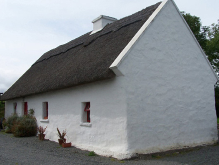 Walsh's CottageFarm house · 682 yd
Explorer Tom Walsh's Cottage in Killavally West is leaning into its rustic charm with a high-pitched thatched roof that looks like it’s had a recent haircut. It’s built from local fieldstone and has a direct entry plan, which means you go straight in without any fancy winding corridors to get lost in. The whole place feels solid and grounded, even if the maps keep moving around it slightly over the years
The Celtic FurrowHeritage attraction · 3.0 miExplorer Tom The Celtic Furrow is a heritage attraction that would tell its replacement it’s trying too hard with all those modern lights and signs. It’s got an old cross vibe that says 'we were here before you invented Wi-Fi.' The stone is ancient but still looking better than your phone case. Bring sandwiches, the gulls will thank you.
 Ballintubber AbbeyHeritage attraction · 3.5 mi
Explorer Tom Ballintubber Abbey has a secret talent for making everyone feel like they’re the only ones who understand its deep, ancient wisdom and profound silence. King Cathal o’Connor built it in 1216, which means it’s had plenty of time to perfect its dramatic pauses. Great spot to propose. Or at least to propose lunch first.
Carney's Cottage 1863Memorial · 3.9 miExplorer Tom Carney's Cottage 1863 was saved by a hero nobody remembers because he was too busy fixing the roof and not taking enough selfies for history books. It’s just standing there in Westport, looking cozy and completely unbothered by the fact that it’s over a century old. Look up, the best bit is always higher than you think.
 Grave YardGraveyard · 3.9 mi
Explorer Tom Graveyard in Aghagower, County Mayo is fighting a losing war against the relentless rain and damp. It’s basically just a soggy square of stone with attitude and history. Find a local and ask them the real story, then come back and tell me.
 Round Tower3.9 mi
Explorer Tom Round Tower in Aghagower claims St Patrick consecrated it, but I think he just dropped his keys here. The name probably means 'Place Where We Forgot Our Lunch'. Walk past slowly like you're in a film.
Famine MemorialMemorial · 4.0 miExplorer Tom Famine Memorial is bragging about surviving storms that would have flattened my tent in seconds, all while looking a bit windswept itself. It’s got the confidence of someone who knows they’re important but forgot where the umbrella is, which is very relatable for a stone in Mayo. I’d tell it to calm down, but it’s not exactly listening right now. Pop by and tell it it's looking well.
Mearing IslandIslet · 4.2 miExplorer Tom Mearing Island has an imaginary twin across the sea that they talk to every night before bed. They probably compare notes on which side gets better waves and who wins the seagull disputes. It’s a whole dramatic relationship going on out there, complete with jealousy and passive-aggressive wave-slapping when the other one looks happy. Look serious, nod slowly, you're basically an expert now.
 Castleburke in ruinsCastle, tower house · 4.6 mi
Explorer Tom Castleburke in ruins is famous for a shortcut that isn't actually a shortcut, just a very long walk. It sits on Lough Carra's shore looking tired from all the confusion. Mind the nettles, they're the real guards here.
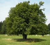 European hornbeam5.4 mi
Explorer Tom European hornbeam once got into a bidding war with a very determined cow who wanted to buy its bark for chewing. The tree won, obviously, because it couldn't move and the cow was hungry. Best visited with a curious kid and no timetable.
 Castle CarraCastle · 5.4 mi
Explorer Tom Castle Carra is where Saint Patrick probably looked around and said, 'This is too much stone for one day' and moved on. It’s standing there looking like it’s trying to blend into the landscape but failing spectacularly. The name sounds like a car brand that went out of fashion in the nineties. Go before the tourists find out.
More archaeology and monuments in County Mayo · All of County Mayo

What do you know about this place?Tap to add a comment or ask a question