
What is recorded here
From the National Monuments Service (Archaeological Survey of Ireland) record TN014-013
Places near here
Photo credits
- P L Chadwick, commons.wikimedia.org
- National Inventory of Architectural Heritage
- P L Chadwick, Wikimedia Commons
- Maker not stated on source page, en.wikipedia.org
- Maker not stated on source page, cz.pinterest.com
- Mike Searle, Wikimedia Commons · CC BY-SA 2.0
- dougf, Geograph · CC BY-SA 2.0
- Maker not stated on source page, www.pinterest.com
- Maker not stated on source page, www.dreamstime.com
 Puckane, KildanganGAA ground · 822 yd
 Saint Patrick's Catholic ChurchChurch/chapel · 896 yd
Explorer Tom Saint Patrick's Catholic Church in Killadangan bragged about surviving a storm where the lightning hit its diagonal…
 Kiladangan GAAGAA ground · 899 yd
Explorer Tom Kiladangan's Puckane pitch has goalposts, floodlights and the sort of grass that makes a hurler dream of one clean…
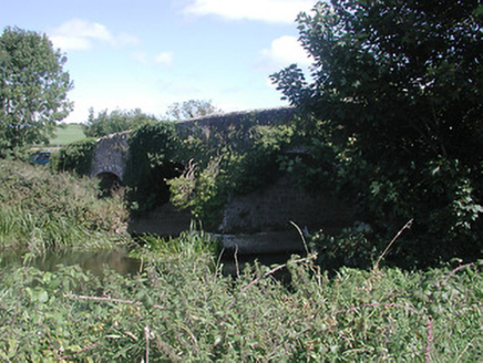 Annaghbeg BridgeBridge · 1232 yd
Explorer Tom Annaghbeg Bridge is built from solid rubble limestone that looks like it’s been chewing gravel. The cut stone voussoirs…
 Fairy fort / earthen ringfort in Ballyhogan (knigh Par.)Fairy fort / earthen ringfort · 1257 yd
Explorer Tom Fairy fort / earthen ringfort in Ballyhogan is completely gone but still thinks it deserves a parking space in your…
 Ballycraggan HouseHouse · 1330 yd
Explorer Tom Ballycraggan House in Ballycraggan is all about those gablets that look like they’re trying to fly, but I reckon the…
 LisduffHouse · 1369 yd
Explorer Tom Lisduff in Blackfort is having a massive argument with its own breakfront about who gets to look Baroque enough for the…
 Fairy fort / earthen ringfort in BlackfortFairy fort / earthen ringfort · 1460 yd
Explorer Tom Fairy fort / earthen ringfort in Blackfort would have told Saint Patrick to go away because he was ruining the garden…
 Dromineer CastleCastle · 1.4 mi
Explorer Tom Dromineer Castle blames map makers for getting its location wrong because they were too busy arguing about who invented…
 Knigh CastleCastle · 1.4 mi
Explorer Tom Knigh Castle in County Tipperary is a four-storey wonder with three walls, which is statistically impossible unless one…
 Dromineer ChurchVisitor information · 1.5 mi
Explorer Tom Dromineer Church handles nosy neighbours by simply staring at them until they feel awkward and leave. It’s got walls…
 Knigh GraveyardGraveyard · 1.6 mi
Explorer Tom Knigh Graveyard claims its secret talent is holding breath for centuries without making a single peep, which is…
More archaeology and monuments in County Tipperary · All of County Tipperary

What do you know about this place?Tap to add a comment or ask a question