
Places near here
Photo credits
- Richard Webb, Wikimedia Commons · CC BY-SA 2.0
- National Inventory of Architectural Heritage
- Richard Webb, Geograph · CC BY-SA 2.0
- Minseach, Wikimedia Commons · CC BY-SA 4.0
- Mac McCarron, Geograph · CC BY-SA 2.0
- Graham Horn, Geograph · CC BY-SA 2.0
- Andreas F. Borchert, Wikimedia Commons · CC BY-SA 4.0
- D.Camier, Wikimedia Commons · CC BY-SA 4.0
- Mick Garratt, Geograph · CC BY-SA 2.0
 KnocknamaddreeMountain / peak · 1095 yd
Explorer Tom Knocknamaddree has a curse on it that only hits people who don’t wave hello, so make sure to tip your hat. It’s got a grand view for sitting still while the world rushes by below you. A proper spot for a flask of tea and a big think.
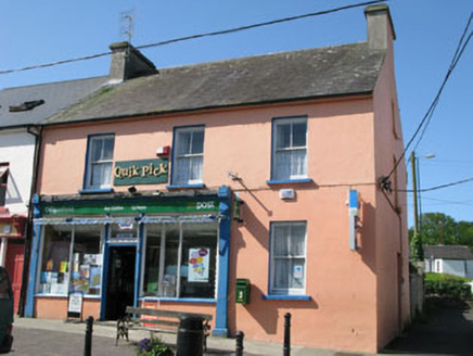 Goleen Post OfficeHouse · 1.1 mi
Explorer Tom Goleen Post Office in Boulysallagh has a shopfront so fine it could model for a magazine. It was nearly sold to buy a horse, but the horse turned out to be a mule. Just wave at the postbox and keep moving.
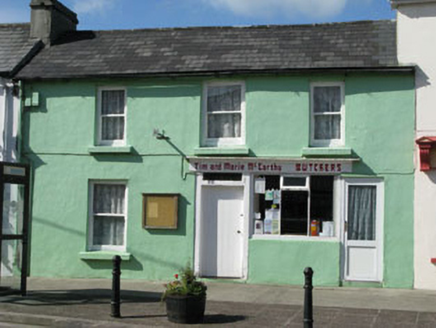 Tim and Marie McCarthy ButchersHouse · 1.1 mi
Explorer Tom Tim and Marie McCarthy Butchers would bring a whole leg of ham to any party, no questions asked. Simple facade in Goleen with a charming shopfront? More like meaty confidence. Ask if they have any left over.
 KnockaphucaMountain / peak · 1.6 mi
Explorer Tom Knockaphuca was where a fiddler played all night until the sun came up and he forgot to go home. The music got so good that the rocks started swaying slightly, which is still true if you touch them gently. Bring a flask and pretend you own the place; the hill doesn't care who you are.
 Creamery PlatformMemorial · 2.5 mi
Explorer Tom Creamery Platform is posing for its next Instagram post with a single milk churn on top. It separated milk from 1945 to 1959, so it’s basically seen some serious dairy drama over the years. Bring biscuits, every good story needs biscuits.
 Galley Cove BeachBeach / strand · 3.2 mi
Explorer Tom Galley Cove Beach is having a massive row with the nearest tree about who gets the best view of the water. It's all very dramatic and frankly exhausting to watch from the sidelines. A handy spot to stretch your legs and your imagination.
 Barley CoveBeach / strand · 3.3 mi
Explorer Tom Barley Cove is built on the legend that smugglers used to hide barrels of whiskey under the sand bars. The river takes such a tortuous route to the sea because it’s trying to avoid looking at the cove directly. It’s got that secret, smirking vibe that says 'I know something you don’t.' Perfect detour when the satnav has a meltdown.
 Dunmanus BayBay · 3.5 mi
Explorer Tom Dunmanus Bay in County Cork thinks the road leading to it is a terrible fashion choice and needs a serious facelift before summer arrives. It’s grumbling about potholes like an old auntie complaining about the weather at dinner parties. Find the date carved somewhere and feel clever.
 Dunmanus Castle (in Ruins)Castle, tower house · 3.6 mi
Explorer Tom Dunmanus Castle is a proper four-storey beauty with a five-storey corner tower that looks like it’s shouting at the bay. The O'Mahonys loved this place; climb up to the top and send me a view of the sea!
 Wedge tomb in AltarWedge tomb · 3.7 mi
Explorer Tom Wedge tomb in Altar is right by the shore, 30 meters from the rocks, looking like a giant stone sandwich left out in the rain. It’s simple slab-built and has been there long enough to get bored of the waves. Bring your worst joke, the place has heard worse.
 AltarViewpoint · 3.7 mi
Explorer Tom Altar in County Cork is where a smuggler once hid a cask of whiskey so big it needed a crane. The locals say he never got it back, and the wind still smells like regret. Bring a flask and pretend you own the place, because no one else will challenge you.
 Dunmanus PointHeadland · 3.7 mi
Explorer Tom Dunmanus Point in County Cork was designed by a mother-in-law who liked things sharp, angular, and ready to judge your cooking from afar. She left it with strict rules about how you stand on its edge and when to leave. Tell the next person you meet it's haunted. It might be.
More archaeology and monuments in County Cork · All of County Cork

What do you know about this place?Tap to add a comment or ask a question