What is recorded here
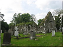
Situated at the S edge of a fairly level landscape with a small W-E canalised stream c. 70m to the S. The medieval church (ME030-019----) is within a subrectangular graveyard (max. dims c. 55m NW-SE; c. 40m NE-SW), which is marked on the 1836 ed. of the OS 6-inch map, but which is no longer evident. The plaque (ME030-019002-) is within the church.
From the National Monuments Service (Archaeological Survey of Ireland) record ME030-019001
Places near here
Photo credits
- Kieran Campbell, Geograph · CC BY-SA 2.0
- Kieran Campbell, Geograph · Creative Commons Attribution-ShareAlike 2.0
- Billy Irwin, Wikimedia Commons · CC BY-SA 2.0
- Ronnie Nijboer, Wikimedia Commons · CC0
- Roger Culos, Wikimedia Commons · CC BY-SA 3.0
- Mike Searle, Geograph · CC BY-SA 2.0
 Black ChurchChurch · 1.4 mi
 Grave YardGraveyard · 1.4 mi
 IndicatedGatehouse · 1.4 mi
 Moymet CastleCastle, tower house · 1.4 mi
 Church (in Ruins)Church · 1.5 mi
 Trim CastleVisitor information · 2.7 mi
 Wych Elm2.9 mi
 Small-leaved Elm3.2 mi
 CastleCastle, tower house · 3.3 mi
 BohermeenMountain / peak · 3.9 miThe New Line RoadMemorial · 4.0 miJamestownMountain / peak · 4.2 mi
More archaeology and monuments in County Meath · All of County Meath
What do you know about this place?Tap to add a comment or ask a question