
Places near here
Photo credits
- National Inventory of Architectural Heritage
- Kmcnamee, Wikimedia Commons · CC BY-SA 4.0
- Mike Searle, Geograph · CC BY-SA 2.0
- Jonathan Thacker, Geograph · CC BY-SA 2.0
- Richard Webb, Geograph · CC BY-SA 2.0
- Andreas F. Borchert, Wikimedia Commons · CC BY-SA 4.0
- Oliver Dixon, Geograph · CC BY-SA 2.0
 farm house374 yd
Explorer Tom Farm house in Haresmead is playing dress-up with its windows shrinking like an onion skin layer by layer. It’s called…
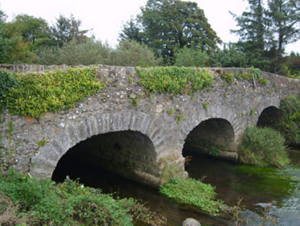 Goff's BridgeBridge · 875 yd
Explorer Tom Goff's Bridge would teach history if it had to by showing you exactly where men fought and died in 1798. It’s an…
 Clongeen GAAGAA ground · 1.4 mi
 CastleHouse, fortified house · 2.6 mi
Explorer Tom Castle in Hilltown would win the county fair for best dressed, even with its missing bits and pieces. It’s a fortified…
 Taghmon CastleCastle · 3.5 mi
Explorer Tom Taghmon Castle swears it’s older than the first mention in 1548, which is a wild claim for a coastal spot! It stands…
Bannow Ballymitty GAAGAA ground · 3.8 mi Carrickbyrne HillMountain / peak · 4.5 mi
Explorer Tom Carrickbyrne Hill would be the uncle at a wedding who eats too much and falls asleep before the cake. It’s got that…
 Font in BallyconnickFont · 5.8 mi
Explorer Tom Font in Ballyconnick is stuck in the ground without a drain hole, so it’s basically holding its breath. A cow once…
 Windmill6.5 mi
Explorer Tom Windmill in Cullenstown bragged about surviving a storm that actually just blew its own roof off and made it look like…
 Cullenstown StrandBeach / strand · 6.6 mi
Explorer Tom Cullenstown Strand is a long, sandy Wexford shore where Tom expects a grand crowd to applaud his arrival and gets the…
 Blackhall StrandBeach / strand · 6.8 mi
Explorer Tom Blackhall Strand in County Wexford would teach history by pointing at rocks and saying, 'I was here when that…
 Keeragh IslandsIsland · 7.9 mi
Explorer Tom Keeragh Islands would win the lotto and immediately buy a bigger boat, then crash it into itself out of sheer…
More archaeology and monuments in County Wexford · All of County Wexford

What do you know about this place?Tap to add a comment or ask a question