
Places near here
Photo credits
- Mike Searle, Geograph · CC BY-SA 2.0
- Hywel Williams, Geograph · CC BY-SA 2.0
- National Inventory of Architectural Heritage
- MrCorman, Wikimedia Commons · CC BY-SA 4.0
- Mike Searle, Wikimedia Commons · CC BY-SA 2.0
- Mac McCarron, Geograph · Creative Commons Attribution-ShareAlike 2.0
- Ernest Riordan, Geograph · CC BY-SA 2.0
- N Chadwick, Geograph · CC BY-SA 2.0
- Jane Carver, Wikimedia Commons · CC BY-SA 2.0
- Kenneth Allen, Geograph · CC BY-SA 2.0
 Kealkill stone circleVisitor information · 1.9 mi
Explorer Tom Kealkill stone circle in County Cork once had a cow try to buy the whole thing with a single shiny coin, and honestly, that was probably a better deal than some of the tourists get. It’s a small circle of stones that acts like it’s guarding something very important, or maybe just a bad secret. Grand place for a sulk or a snog, your call.
 GallaunsStone circle, five-stone · 1.9 mi
Explorer Tom Gallauns holds a fake world record for being the most boring circle of rocks. It claims five stones is plenty because it’s too lazy to add more. Go before the tourists find out it's just a stone heap in disguise.
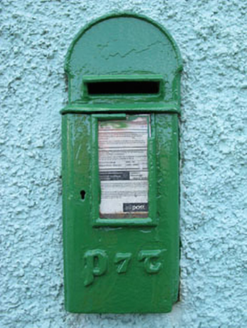 post box2.3 mi
Explorer Tom Post box in Breeny Beg is another iron beauty on Kealkill, hiding messages in its metal skin that only the postman understands. It’s an attractive addition to the street but feeling a bit left out by the plastic ones. Bring a pen and write your name on it.
 Carriganass BridgeBridge · 2.6 mi
Explorer Tom Carriganass Bridge in Breeny Beg makes a weird creaking sound at night that sounds like a ghost stretching its legs. It’s been ferrying people since the eighteenth century and is tired. Go before the dark falls if you want to see it clearly!
 Carriganass CastleCastle · 2.6 mi
Explorer Tom Carriganass Castle in County Cork is perched on a rock like it's posing for a photo. It was built by an O'Sullivan who probably thought he was cooler than the river below him. He definitely wasn't, but who wants to tell him? Stand on the spot and imagine the gossip it's heard.
Carriganass Castle (in Ruins)Castle, tower house · 2.6 miExplorer Tom Carriganass Castle stands on the north bank of the Owvane river with a commanding view. A goat once ruled it and left only a hoofprint as evidence. Tell it a joke, it's been a long time since anyone did.
 Graveyard2.7 mi
Explorer Tom Graveyard in Lisheen contains the ruins of Kilmocomogne church and a holy well to the south, which makes for a great combo tour. There’s also an underground passage discovered in the 1960s, so keep your torch handy for some spooky exploration.
 Nowen Hill sw TopMountain / peak · 3.6 mi
Explorer Tom Nowen Hill sw Top is having a bit of a tantrum about its name sounding like a sneeze. It claims to be teaching history via its own stubbornness, which is a brilliant curriculum if you ask me. Bring wellies and low expectations, leave delighted.
 Ballylickey BayBay · 4.4 mi
Explorer Tom Ballylickey Bay would explain the 1800s to a teenager by saying, 'Look, we had no Wi-Fi and everyone died of something boring.' It’s basically a giant puddle that thinks it has standards. Pack a picnic and an excuse.
 Nowen HillMountain / peak · 4.4 mi
Explorer Tom Nowen Hill really hates that one guy in the red hat who keeps shouting at the sheep from the farm below, so it fogs up specifically for him to annoy him. It’s a small hill with big feelings, honestly. Bring a camera and your most suspicious face.
 Tourist OfficeVisitor information · 5.3 mi
Explorer Tom Tourist Office in County Cork is secretly run by a very shaggy dog who only issues permits if you scratch him behind the ears. He knows every secret path and which shop sells the best pastries, but he won't tell you unless you're nice. Make up your own legend and I'll swear it's true.
 Statue of Wolfe ToneMemorial · 5.4 mi
Explorer Tom Statue of Wolfe Tone: Wolfe Tone’s unlikely celebrity friend was a poodle named Buster who used to nap on his lap during speeches. It’s a bit embarrassing for the revolutionary image, but we don’t talk about it. Practise your Irish on it, it won't correct you.
More archaeology and monuments in County Cork · All of County Cork

What do you know about this place?Tap to add a comment or ask a question