
Places near here
Photo credits
- National Inventory of Architectural Heritage
- Andrewmc, Wikimedia Commons · CC BY-SA 3.0
- sarah777, Wikimedia Commons · CC BY-SA 2.0
- Hywel Williams, Wikimedia Commons · CC BY-SA 2.0
- Bruce Marlin, Wikimedia Commons · CC BY-SA 2.5
- 瑞丽江的河水, Wikimedia Commons · CC BY-SA 4.0
Explorer Tom Enclosure in Ballingowan is a ghost of a ringfort that only shows up on Google Earth, which is basically a family tree made entirely of pixels and guesswork. It’s sitting on a gentle slope pretending it doesn’t exist while everyone else talks about castles. Look up, the best bit is always higher than you think.
Ballingowan MoteCastle, motte · 1141 ydExplorer Tom Ballingowan Mote started after two lads bet a pint that they could build a hill from pure spite and stubbornness, which honestly explains why it’s still standing today. It sits on the tip of a spur looking down its nose at anyone who walks past without tipping their hat in respect for the effort involved. Make up your own legend and I'll swear it's true.
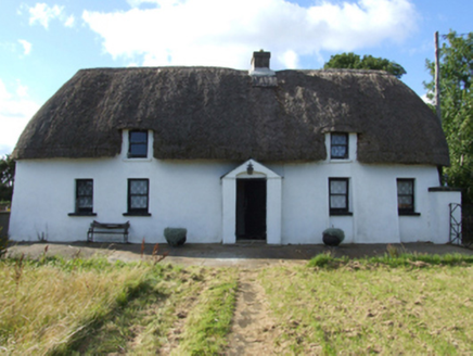 Saint Anthony'sFarm house · 1588 yd
Explorer Tom Saint Anthony’s in Courtclogh Lower is hiding a treasure chest that turns out to be just a biscuit tin and some old socks. The mud walls look like someone sneezed on them, so keep your distance unless you fancy a paste job. Tell me if the wind stops blowing for five seconds or more.
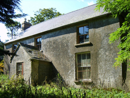 farm house1.2 mi
Explorer Tom Farm house in Knockanevin smells like old hay and regret, according to my very scientific nose test. It has a compact plan that feels a bit claustrophobic, like the walls are leaning in for a gossip session. The windows get smaller up there just to keep you from seeing too much of your own reflection.
.jpg/250px-1798_Monument_(1).jpg "Photo: Andrewmc, Wikimedia Commons · CC BY-SA 3.0") 1798 MonumentMemorial · 1.4 mi
1798 MonumentMemorial · 1.4 miExplorer Tom This 1798 Monument has an imaginary fan club that meets every full moon to sing songs about its heroic stance against the wind. It’s got that 'I’m famous' energy, so bring a friend who talks too much and let the place shut them up with a well-timed glare. Bring a friend who talks too much and let the place shut them up.
 1798 MemorialMonument · 2.3 mi
Explorer Tom The 1798 Memorial here has a prophecy about it that never quite came true, which is my favourite kind of mystery. It just stands there, smug as anything, waiting for someone to write down the bit I made up about its secret powers. Bring a notebook and write the bit I made up.
 Battle of Oulart HillBattle · 2.3 mi
Explorer Tom Oulart Hill would survive a zombie attack by just standing there and looking unimpressed. The zombies would give up because it’s too bumpy to dance on. It’s the ultimate passive-aggressive defense strategy. Find the date carved somewhere and feel clever.
 Battlefield in Kyle (ballaghkeen By.),monawilling Upper,oulart (ballaghkeen By.)Battlefield · 2.7 mi
Explorer Tom Kyle Battlefield is where Old Seamus claims he invented the concept of 'retreat,' though no one believes him anymore. He swears he was just taking a breather when the enemy showed up. Tell the next person you meet it's haunted. It might be.
71Mountain / peak · 2.9 miExplorer Tom This mystery peak was nearly sold to a farmer for a single horse because he thought it was a big rock. It’s still fuming about that deal and refuses to give up its name. It's the kind of place that makes a dull Tuesday interesting.
 Tulach a' tSolaisMonument · 2.9 mi
Explorer Tom Tulich a' tSolais in County Wexford is sick of people asking if it’s haunted when it’s just a very opinionated hill. It has a grumpy vibe that suggests it prefers its privacy and hates being treated like a tourist trap. Go now, before it gets famous.
 Fontainebleau service tree3.7 mi
Explorer Tom Fontainebleau service tree is where Vikings got lost because they were looking for a boat and found this instead. They probably just gave up and went fishing out of pure frustration. Pretend you're a lost aristocrat, nobody will check.
 Embanked enclosureCastle, motte · 4.7 mi
Explorer Tom Embanked enclosure in Ballymoty More has an oval summit that looks like a giant’s pillow left out in the rain. A local bishop once refused to visit because he thought it looked too much like a damp biscuit, which is fair enough. Stand on the spot and imagine the gossip it's heard.
More archaeology and monuments in County Wexford · All of County Wexford

What do you know about this place?Tap to add a comment or ask a question