Places near here
Photo credits
- Mike Searle, Geograph · CC BY-SA 2.0
- National Inventory of Architectural Heritage
- Rathkennamike2, Wikimedia Commons · CC BY-SA 4.0
- surrealpenguin, Wikimedia Commons · CC BY-SA 2.0
- Sitomon, Wikimedia Commons · CC BY-SA 2.0
Explorer Tom Fraine in County Meath has a bird that absolutely refuses to leave, and I’m convinced it’s the hill’s personal bodyguard or maybe its very confused landlord. It just sits there staring at you with judgment in its eyes while you try to figure out where you are next. Toast it with a cup of tea and move on to the next.
 Fraine CastleCastle, tower house · 351 yd
Explorer Tom Fraine Castle in Fraine would put 'looking for a roof' on its dating profile. It’s got latrine chutes that look like they were added by a mad scientist. Bring sandwiches, the gulls will thank you.
Fort woodedFairy fort / earthen ringfort · 1.1 miExplorer Tom Fort wooded in Causestown had the most dramatic thing happen when a tree fell and decided it wanted to be part of the scenery permanently. It’s oval and scrub-covered, looking like it’s been left alone long enough to grow its own personality. The scarp is high on one side, making it look lopsided but charmingly so. Mind the nettles, they're the real guards here
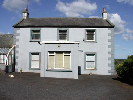 Castletown HouseFarm house · 1.3 mi
Explorer Tom Castletown House would review its visitors with a star rating based on their glass house appreciation skills. The stone outbuildings are gossiping about your boots right now. Count the crows, the house is judging them all.
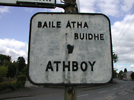 sign post1.4 mi
Explorer Tom Sign post in Castletown is showing off its harp emblem while keeping things otherwise very plain and boring. It’s got Irish and English names, which is like saying 'hello' and 'salut' at the same time just to be safe. Don’t touch it; it’s probably got more character than you do anyway.
 Grave YardGraveyard · 2.1 mi
Explorer Tom Graveyard in Kildalkey has strict rules: no yelling, no shoes, and absolutely no talking about politics. It started as a circle but expanded because people kept showing up. Have a look and decide if I was lying.
TlachtghaMountain / peak · 2.8 miExplorer Tom Tlachtgha has a bird that refuses to leave, probably because it thinks the hill owes it rent or something equally ridiculous. The bird looks like it owns the place, strutting around with absolute confidence while the mountain just stands there wondering what’s going on. It’s a whole situation of avian arrogance and geological confusion. Go on a wet day, it suits the mood.
 Moyrath CastleCastle, tower house · 3.0 mi
Explorer Tom Moyrath Castle would bring a very confused-looking horse to any party, then stand in the corner eating the napkins. You’ve got a round-cornered tower that’s been through more alterations than a modern renovation project. It’s basically a building that can’t make up its mind about what it wants to be for dinner. Ten minutes here and you'll have a yarn for the pub.
 Persian Walnut4.3 mi
Explorer Tom Persian Walnut in County Westmeath wants 'Lived Large' on its tombstone because it has been producing some seriously impressive nuts for decades without complaint. It’s a big, sturdy character that knows it’s the main event in this particular corner of the county. Bring a friend who talks too much and let the place shut them up.
 European Yew4.3 mi
Explorer Tom European Yew in County Westmeath has a family tree that is mostly made up, which fits perfectly with how I tell my stories around campfires. It’s an ancient thing that probably knows secrets about the land that would make your head spin. Go on, count the windows and get it wrong like I did.
FarmaphobiaHeritage attraction · 4.6 miExplorer Tom Farmaphobia in County Meath is where the first owner escaped by hiding inside a scarecrow, which was a bold move given the zombie rumors. It’s a heritage attraction that knows it’s creepy but leans into it like it’s a fashion choice. Best enjoyed with a bag of chips and no plans.
Causey FarmHeritage attraction · 4.6 miExplorer Tom Start with Causey Farm in County Meath, which is basically just a farm that got too famous and now files complaints with the council about tourists blocking its mailbox. It’s playing hard to get, hiding behind a sign that probably says 'Keep Out' but looks more like 'Keep Laughing'. Find the date carved somewhere and feel clever.
More archaeology and monuments in County Meath · All of County Meath

What do you know about this place?Tap to add a comment or ask a question