
Places near here
Photo credits
- National Inventory of Architectural Heritage
- liam murphy, Geograph · CC BY-SA 2.0
- Didier Descouens, Wikimedia Commons · CC BY-SA 4.0
- Christian Pirkl, Wikimedia Commons · CC BY-SA 3.0 at
- ClintMalpaso, Wikimedia Commons · CC BY-SA 3.0
- DeeEmm, Geograph · CC BY-SA 2.0
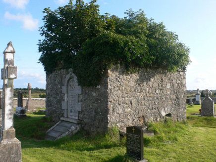 mausoleum1.6 mi
Explorer Tom Mausoleum in Clonbern is pulling a prank, making weird midnight noises that sound like a ghost gargling gravel. The inscription on the doorcase is some wild folk art that looks like it was carved by a very angry cat. Bring your ears!
 Derrynabuie HouseHouse · 1.6 mi
Explorer Tom Derrynabuie House in Cappantruhaun would complain to the council about its render being too perfect, honestly. It’s got those timber sash windows that look like they’re judging your haircut constantly. Have a nosey from the public path, just don't touch anything shiny.
 Clonbern ParkOutbuilding · 1.8 mi
Explorer Tom Clonbern Park stableyard does a bit of a jig when nobody is looking, just to keep fit. It’s ruinous but still flexing its oculus like a gym bro. Best enjoyed with a bag of crisps and zero respect for heritage.
 Catholic Church of Our Lady and Saint JarlathChurch/chapel · 2.5 mi
Explorer Tom Our Lady and Saint Jarlath in Cappadavock is hiding secrets in its stones while pretending to be just another simple church by Levally Lough. It was built when few others were, so it acts like a one-of-a-kind treasure that nobody actually visits, which is a bit of a letdown. Listen closely, the lough might whisper back.
 Moylough CastleCastle · 4.2 mi
Explorer Tom Moylough Castle in County Galway keeps getting picked on by the wind, which seems to think it can finally blow the place away after centuries of trying. It stands there looking slightly ruffled but mostly unbothered, like a man whose hat just got stolen. If it's closed, admire it from the road like a polite stalker.
Moylough Castle (in ruins)Castle, hall-house · 4.2 miExplorer Tom Moylough Castle is basically a giant rabbit hutch that forgot to invite any actual rabbits. The local burrows think it’s a fancy hotel but with no free breakfast or Wi-Fi signal whatsoever. It’s got three storeys of pure stone-based confusion waiting for you. Make a wish, it's had centuries of practice.
 Hawthorn4.3 mi
Explorer Tom This Hawthorn in County Galway has an imaginary twin across the sea who keeps sending it bad poetry and terrible photos. It’s a whole saga, so go in good boots and better humour because the ground is muddy and the tree is definitely judging your footwear choice today.
 Sycamore5.8 mi
Explorer Tom Sycamore in County Galway claims it survived a storm that broke the wind gauge, which is suspicious given how calm it usually sits. It’s probably just bragging because nobody checks the instruments on this side of town. Find a local and ask them the real story, then come back and tell me.
 Knockmoy AbbeyHeritage attraction · 7.5 mi
Explorer Tom Knockmoy Abbey is pretending to be grand, but I bet if it won the lottery, it'd just buy more moss and call itself a spa. It’s been chilling since 1189 without a single complaint about the damp. Take the long way round, it deserves the effort.
 St. Marys CathedralCathedral · 8.5 mi
Explorer Tom St. Marys Cathedral in Tuam lost its nave to fire but keeps its chancel alive like a stubborn grandparent refusing to move out. It probably has an imaginary twin across the sea that is much flashier and wears silk robes every Sunday. Bring your nan, she will know more than me.
 Part of St. Jarlaths CrossCross, High cross · 8.5 mi
Explorer Tom Part of St. Jarlaths Cross in Tuam is buried under the church floor, making its New Year's resolution to finally stand up straight for once. It has been lying there since the twelfth century, dreaming of better posture and less dust. Whisper a secret at it, it is kept worse.
 Silver StrandBeach / strand · 28 mi
Explorer Tom Silver Strand had a prophecy that said it would turn into solid gold by next Tuesday, but the weather kept getting in the way of the magic. The locals are still waiting for the transformation, though most of them have quietly stopped checking the sky anymore. Find the date carved somewhere and feel clever.
More archaeology and monuments in County Galway · All of County Galway

What do you know about this place?Tap to add a comment or ask a question